I’m not even sure how you could get such a composition – coalescing from a particularly iron poor planetary nebula, perhaps? But given how Earth’s mantle is dominated by olivine and its pressure-induced phase changes, there could be profound differences in how an olivine-free mantle convects and loses heat.
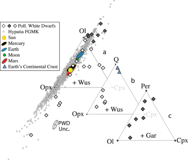
As this figure from the paper shows, the data also point to another kind of rocky exoplanet rich in periclase (MgO) rather than orthopyroxene. In other words, a significant non-silicate phase!
Figure 3 of Putirka & Xu (2021) plotting estimated compositions of exoplanetary mantles (large diamonds) on one of 3 ternary diagrams. Top left: components are Olivine, Orthopyroxene (Opx) and Clinopyroxene (Cpx), like the Earth’s mantle. Note how the light grey and dark grey diamonds plot way outside the ternary diagram, indicating at least one of the three components is not present. Centre: components are Quartz (replacing Olivine as in Earth’s continental crust), Opx, and Cpx. Bottom right: olivine, Cpx and periclase (MgO) replacing Opx.
So what does this mean? The authors suggest that “quartz-rich mantles might create thicker crusts, while the periclase-saturated mantles could plausibly yield, on a wet planet like Earth, crusts made of serpentinite.”
Of course, there are some sizeable (acknowledged) caveats, given the rather extreme detection method. We’ll have to see whether these inferences stand up to scrutiny. But it’s yet more evidence that beyond our solar system, many surprises about the way planets work await.
I’ve been known on occasion to mock fusion for being eternally 25 years in the future, and this article on the latest potential advances doesn’t really help me assess how credible the people and approaches that star in it actually are. But there is some eyebrow-raising information in the background that gives some context to the long wait for the fusion dawn.
In particular, a report from the U.S. Energy Research and Development Administration in 1976 projected that if $9 billion per year was spent on research, practical fusion energy could be achieved by 1990. Reduce that to $1 billion per year, and the projection was “Fusion Never.” And guess what?
“[$1 billion]’s about what’s been spent…Pretty close to the maximum amount you could spend in order to never get there.”
The current annual spending of US government on fusion research: $670 million. In contrast, the estimated annual cost of US fossil fuel subsidies is $650 billion.
There is, of course, no proof that $9 billion/year would have actually moved working fusion’s perpetually 25 years away horizon any closer. But opting for ‘definitely not enough money to work’ whilst demonstrating the ability to throw an order of magnitude more money elsewhere in the energy sector is, at best, poor strategic foresight. At worst, it looks a lot like what you’d do if you wanted to make it look like you were pushing for an energy breakthrough without materially threatening the status quo.
With the incidental bonus of turning that potential breakthrough into a punchline. My scoffing suddenly feels a little hollow.
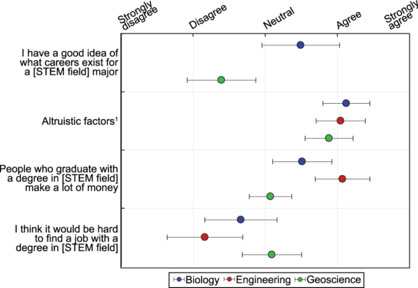
The ‘you get to play outside!’ pitch is a popular one in geoscience recruitment, but these data support the notion that this is not broadly appealing beyond a self-selecting few.
More pertinently, digging into the data a bit more, it seems that the problem is not that students feel a career in geoscience can’t do some societal good (2nd row of the figure below), but that they’re really unsure how (1st row, and to some degree also the 4th).
Some of this might be solved by promoting the more altruistic career options made possible by a geoscience degree. But I do wonder if there might also be some deeper structural issues with how we teach Earth Science. Are we really matching our course and degree offerings to these careers, or do we still too narrowly focus on careers in things like mapping and resource exploration, not recognizing how much doing so narrows our pool of potential recruits?
“As a discipline, [Earth Scientists] find ourselves in the strange position of having a role in causing, finding and solving…climate change”
In order to help save the future, we must reckon with our dirty past (and arguably, present). The fact that our degree programs largely look like they did 30 years ago might be one sign that we have yet to fully do so. And perhaps this lack of reckoning further contributes to our struggles with undergraduate enrollment: we are still perceived more as part of the problem than part of the solution.
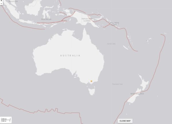
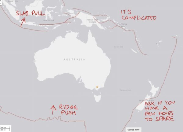
The Melbourne quake is a long way from any recognizable plate boundary – the closest one is more than 1000 km away. It is what we can an intraplate earthquake – one that occurs within a plate interior. This is in contrast to the interplate earthquakes that occur at plate boundaries*.
Map of Australia showing the location of an intraplate earthquake in southern Australia and the plate boundaries that are a long way from where this earthquake is. Source: USGS
To understand why we can get earthquakes inside a tectonic plate, you need to understand why we get earthquakes anywhere. To produce an earthquake, you need:
differential motion between two bits of the crust;
a fault that can accommodate that differential motion by motion along its surface (and has some friction so that the motion is not continuous)
At plate boundaries, the source of differential motion is obvious: you’ve got two chunks of crust moving in different directions. And at its most simple, a plate boundary is a planar break in the lithosphere. Add a bit of friction, and voilà: periodic interplate earthquakes accommodating that motion.
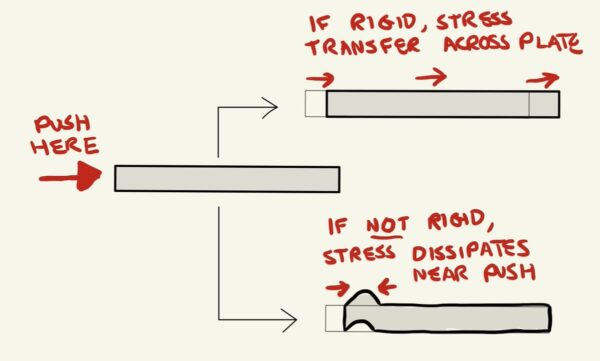
So what’s going on inside plates? The key point is that plates are moving because they are under stress. They are being pushed and pulled at their edges, and are strong enough internally that they translate rather than deform internally in response (in technical terms, they are a stress guide).
Two possible responses to a push on the edge of a block are shown. If rigid, then the whole slab moves sideways; if not rigid, then deformation near the pushed edge dissipates the stress. Sketch by Chris Rowan
For example, the Australian plate is being pushed by a mid-ocean ridge to the south and pulled by a subduction zone to the north, so it is moving north.
Modified from USGS location map.
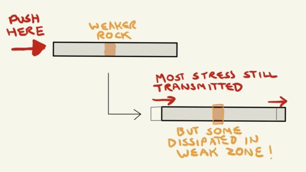
So the rocks that make up the plate are under stress due to these forces. But particularly on continents, the rocks which make up the plate are different depending on where you are, and sometimes bear billions of years’ worth of tectonic scars (pretty much everywhere has been a plate boundary at least once). In other words, there are variations in the strength of the plate.
And if the strength of the plate changes, then so does its response to stress – the strain. Weak bits will deform more than strong bits.
Response to a slab with a weaker zone in the middle; mostly translation, but some deformation in the weak zone. Sketch by Chris Rowan
The differential motions we’re talking about here are very small compared to those that occur across plate boundaries, so it takes much, much longer to build up enough elastic strain on an intraplate fault to generate a significant earthquake. So they are very good at taking us by surprise – because there have been no large earthquakes in the relatively short length of time we’ve been paying any attention to such things, we may not have even considered the risk of an earthquake happening there. When buildings and populations are totally unprepared, even a relatively smallish intraplate earthquake can have an outsize effect.
*If you’re thinking “interplate” and “intraplate” sound very similar and easily confused – yep. I have learnt to my cost that they should be annunciated v-e-r-y s-l-o-w-l-y in lectures.
Via Liz Hide on Twitter, a thought-provoking acknowledgement of the important role the in discovering and excavating the paleontological treasures in many museums’ collections.
On a similar theme, I think of the story of Alfred Wegener and continental drift. The data Wegener used to such great effect to hypothesise the existence and break-up of Pangaea was not collected by him, but collated from many other sources.
Those sources – maps and descriptions of rock units, fossils and geological structures from every continent – surely relied on indigenous knowledge of where to find the good outcrops, and detailed exploration surely occurred with the help of locals.
Wegener’s achievement is not tarnished by acknowledging he was standing on the shoulders of the many people, all over the world, who built the foundations of the geological datasets he used – and we still use today.