
As you watched the videos about flow generation mechanisms, one of the things that you should have noticed is that climate and landscape characteristics influence the way water gets to streams. (And the way water gets to streams influences the shape of the hydrograph.)
Putting it together
Below I go through a list of important climate and landscape factors that influence flow generation, but I’m following in well-trodden footsteps in doing so. Dunne and Leopold (1978) created a classic diagram that puts it all together in a really elegant way. I encourage you to refer back to it as you read through the rest of this post and think about how each factor interacts with the rest to produce the streamflow regime that characterizes a watershed.
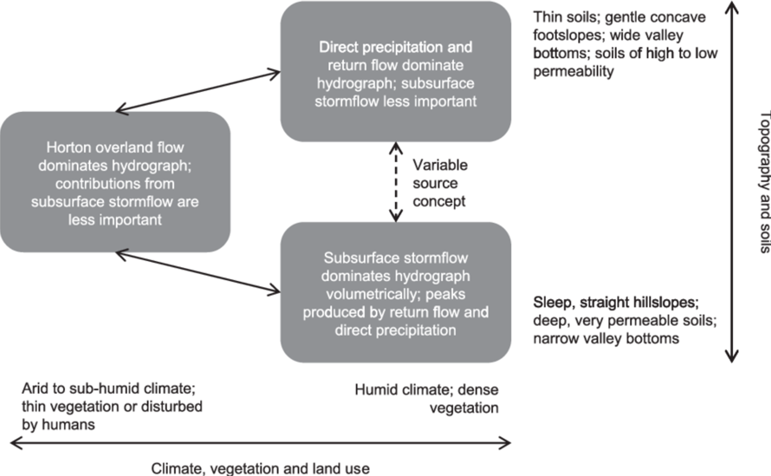
Runoff processes in relation to their major controls. Modified from Figure 9-16 in Dunne and Leopold (1978), by somebody I am not crediting properly because I don’t know who did this version.
Climate
High intensity rainfall is more likely to exceed the infiltration capacity of soils, and lead to infiltration excess overland flow. In semi-arid and arid climates, where it tends to rain infrequently but hard, infiltration excess overland flow can contribute to flash flooding. This can also be true in more humid climates, when low probability, intense deluges occur. Infiltration excess overland flow was probably a major contributor to deadly flash flooding in Ellicott City, Maryland a few years ago, when more than 4.5” of rain fell in less than an hour. [You may want to read my blog post about this extraordinary event. Then contemplate what it means that an almost identical flood happened in the same spot just two years later.]
Rainfall frequency also matters, because it controls how wet the soils are when the next rain storm begins. If soils are fairly damp at the beginning of a storm (they have “high antecedent wetness”), the larger parts of the watershed are more likely to generate saturation overland flow, even if rainfall intensity is low. That’s why, around here, when we we get a series of spring rain storms, the streams get higher with each subsequent storm. If low intensity rain falls infrequently so that there is low antecedent moisture in the soil, much of the water input is likely to be retained in the soil and not even produce much subsurface stormflow. After a long try period, the soil just wets up without producing much stormflow.
Other climate aspects matter too. If you have high potential evapotranspiration, soils will dry out more quickly between storms, reducing the likelihood of saturation. If you have a seasonal snowpack that melts in one big spring thaw, it can saturate the soils and generate overland flow. Perhaps its no coincidence that saturation overland flow was “discovered” in Vermont. Or, if the soils are frozen under the snow, and their infiltration capacity is therefore low, snowmelt can produce infiltration excess overland flow.
Vegetation
To a large extent, vegetation follows climate, but it is also additive. Vegetation can often intercept a large portion of the rainfall, particularly for smaller or lower intensity storms. That reduces the rain hitting the ground, decreasing the likelihood of infiltration excess or saturation overland flow. Vegetation also creates macropores that become preferential flowpaths for water during subsurface stormflow. When land is cleared for urbanization, mining, or agriculture, the interception potential and macropore creation processes are decreased and overland flow becomes more likely — and that’s before we even get to the impacts of the land clearing on infiltration capacity!
Topography
Steep, planar slopes where water in the subsurface is strongly pulled downslope are places that tend to be dominated by subsurface stormflow. Water doesn’t get a chance to stick around long enough to cause saturation very often. Conversely, concave slopes, hillslope hollows, and valley bottoms where topography causes water from large areas to flow towards and concentrate in some spots are places that are more likely to experience saturation and become source areas for streamflow. It doesn’t help that these areas also often have low slopes, which means that they drain more slowly than they would if they were steeper.
This combination of large contributing area and low slope is considered one of the most important predictors of where saturation is likely to occur within a watershed. The formula ln(a/tan B), where a is the upslope contributing area and B (beta) is the local slope angle is called the topographic wetness index. The topographic wetness index underlies the widely used TOPMODEL numerical watershed model and predicts depth to the water table in order to generate overland flow.
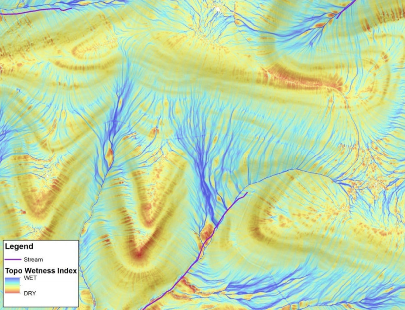
Example of the topographic wetness index variation for a small area within the Susquehanna River basin. From Zimmerman and Shallenberger (2016).
Topography has also been shown to be important in explaining the transit time of water through watersheds.
Soils
Soils matter in a lot of ways. Infiltration capacity is important for determining whether infiltration-excess overland flow will occur. Hydraulic conductivity (and its profile with depth) determines how easily water moves through the soil – and therefore how quickly downslope drainage can occur. Depth is important for determining how likely saturation is to occur (deep, high conductivity soils require a lot of water in order to achieve saturation). You won’t be surprised to learn that soil properties have been used as strong predictors of water transit times
I find this flow chart helpful in thinking about the role of soils and topography in controlling streamflow generation processes.
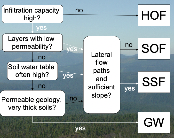
HOF is Hortonian (or infiltration excess overland flow). SOF is saturation overland flow. SSF is subsurface stormflow and GW is groundwater. This diagram is simplified from one presented in Schmocker-Fackel et al. (2007).
Geology
The astute geologists among you will be noting that topography and soils are both, in large part, a function of a watershed’s geologic history. Some even say that geology is destiny.
Below the soil, the hydraulic conductivity of the parent material controls how much deep percolation and groundwater flow can occur. If the bedrock has low hydraulic conductivity, then subsurface stormflow can be set up. However, even in low conductivity rocks, fractures can become important flowpaths for groundwater movement that sustain baseflow in streams. If the bedrock or other parent material has very high hydraulic conductivity (like alluvium, limestone, and basalt do), aquifers may feed streams and rivers, even in the near-absence of other flow generating mechanisms. Such groundwater-dominated streams often have very steady baseflow and very muted stormflow responses to precipitation compared to streams fed by other subsurface stormflow, saturation overland flow, or infiltration excess overland flow.
The peculiar hydrology of groundwater-dominated streams and how their flow was regulated by geology was the subject of my PhD. I studied streams in the central Oregon High Cascades, where winter snow and rain recharge aquifers in Quaternary basalt lavas. These basalts have very high hydraulic conductivity and their groundwater feeds huge springs and supports beautiful rivers. Just to the west of the High Cascades, the Western Cascades has Neogene volcanic rocks that with lower hydraulic conductivity. In the Western Cascades landscapes, subsurface stormflow dominates and the hydrographs are much more responsive to winter storms and summer droughts.
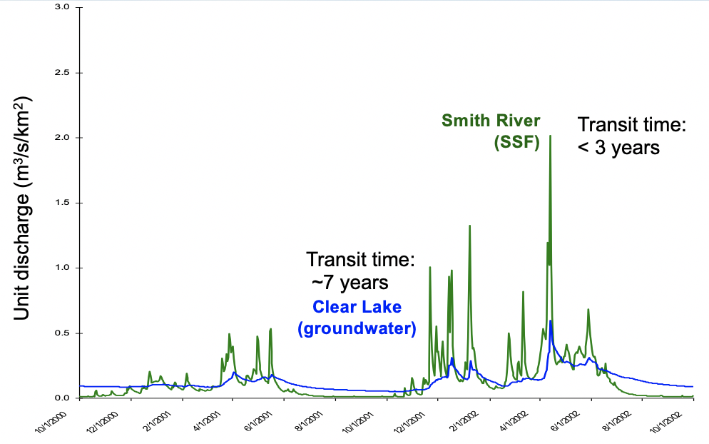
Two streams with adjacent watersheds, similar vegetation and climate, and contrasting geologic history end up with very different hydrographs and transit times.
The Western Cascades landscape is more deeply dissected with steep slopes and deeper, more clay-rich soils than are found in the High Cascades, so that is another proximal control on the Western Cascades hydrology. But we attribute that landscape dissection and soil development to processes related to the slow weathering of the bedrock, altering hydraulic conductivity and with it streamflow generation, in a set of coevolutionary processes.
People
We’ve already alluded to the importance of human activities in altering hydrology and flow generation. Urban areas are characterized by impervious surfaces (pavement and rooftops) that prevent infiltration and promote infiltration-excess overland flow. Mining, military and industrial activities denude the landscape of vegetation and compact the soils, resulting in a greater propensity for overland flow. Forest harvest reduces interception, and can compact the soil. Agricultural practices can radically alter the soil profile, especially when plowing is involved. A compacted layer below the plowing depth can lead to perched saturated zones that can reach the land surface and generate overland flow. And grazing animals compact the soil profile and promote infiltration excess overland flow. Tile drains are giant subsurface preferential flowpaths, just like storm sewers. Basically everything that humans does tends to increase the propensity for rapid drainage of water from the landscape, whether that occurs via overland flow or through anthropogenic macropores (i.e., pipes).
(And that’s what connects what I research now with urban hydrology to the volcano hydrology I used to do…I’m interested in how water moves through landscapes and what that means for streams.)


Nice plan for content warnings on Mastodon and the Fediverse. Now you need a Mastodon/Fediverse button on this blog.