
Infiltration is the act of water moving from the land surface into the soil. Usually, we think about infiltration occurring in response to rainfall, where water is applied over the whole land surface. In that case, infiltration is important because it’s one of the deciding factors in how much rainfall becomes available to plants and groundwater, versus running off over the land surface and potentially causing erosion and flooding.
Infiltration is also important for applications like irrigation – where furrows or drips might apply water to one part of the surface and not others, in order to more efficiently provide water to crops. And infiltration is extremely important for stormwater green infrastructure, like rain gardens and bioretention cells, because we are explicitly designing them to be able to infiltrate water from impervious surfaces like parking lots and roof tops. For green infrastructure, the engineered soil properties are carefully designed to promote just the right amount of infiltration, but the performance of the green infrastructure can also be affected by the infiltration capacity of the surrounding “native” soils and sub-soil.
Based on the above, there are a lot of reasons hydrologists want to be able to measure infiltration, but what exactly are we going to measure? First we need some definitions. Typically, we talk about infiltration as a rate: how fast is water entering the soil? But let’s say it’s raining 0.5 cm/hr, sort of a drizzle. A lot of soils can soak that water in, no problem, giving an infiltration rate that is equal to rainfall rate. So, just talking about infiltration rate might not be helpful. Instead, we talk about infiltration capacity, the maximum rate at which water can enter a soil. But here’s the funny thing, infiltration capacity changes over the course of a rain storm (or irrigation event), so you can’t just measure infiltration capacity at any random point of time and assume you’ve captured a value that applies at other times.
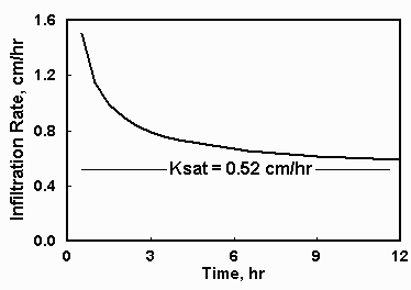
Infiltration rate in an Oklahoma sandy loam decreases over time, in a typical exponential fashion. The asymptote is the saturated hydraulic conductivity. [Image by Oklahoma State U., clink image for source.]
Fortunately, after a long enough period of time, the infiltration capacity starts to asymptotically approach a constant value. We call this steady-state rate the equilibrium infiltration capacity, which conveniently (and logically) is approximately equal to the the saturated hydraulic conductivity. And it’s that steady state rate that we most often want to measure. But how do we do it?
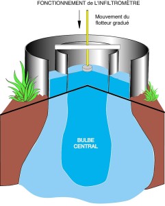
Schematic of infiltration below a double ring infiltrometer. [Image by SDEC. Click image to go to source.]
The most common way to measure equilibrium infiltration capacity is through a double ring infiltrometer. These devices consist of two concentric rings (30 cm and 45-60 cm in diameter) pounded slightly into the soil and filled with water. The water from the outer ring helps wet the soil and infiltrates both vertically and laterally into the dry soil. The infiltration rate is measured in the inner ring , where infiltration and percolation are happening only vertically, thanks to the water from the outer ring doing the lateral movement. Water levels are maintained at the same depths in both rings. We say that outer ring reduces the boundary effects for the measurement of vertical infiltration in the inner ring. You can do infiltration capacity measurements with a single ring infiltrometer, but it’s considered less accurate because of these boundary effects.
Tests can be conducted in two ways: falling head and constant head. In a falling head test, water is added to the rings and the water level declines over time as infiltration occurs. In high infiltration capacity soils, it may be necessary to add water several times before steady state is achieved. Falling head tests require less equipment than constant head tests, but the math is a bit more complicated. In constant head tests, a device called a Mariotte bottle is added to the infiltrometer. A Mariotte bottle releases water so that a constant level (or head) is maintained inside the rings. This simplifies the math considerably.
The video below shows a falling head double ring infiltrometer test. [It’s probably not necessary to watch the whole thing, once you have a sense of how things are going.]
The next video is a fantastically informative USDA instructional video for how to set up and use a constant head double ring infiltrometer. [I personally enjoy watching this one slightly sped up.]
Can’t get enough double ring infiltrometer action? You can check out this video with step-by-step instructions for set up, with some sweet elevator music in the background.
As you are probably starting to realize, it takes a fair amount of work and quite a bit of water to make a double ring infiltrometer measurement. What happens if you need to get into a remote site or have a limited amount of water? Another device, called a Guelph permeameter, can help you out here. The Guelph permeameter works on a similar principle as the infiltrometer, but water coming out of it sets up a wet bulb of a specific known shape, from which you can calculate equilibrium infiltration capacity. With a Guelph permeameter, you make measurements at two different specified heads (usually 5 and 10 cm), and in each case allow infiltration to occur until a steady rate is reached. Then you plug your steady rates and your chosen head values into an equation to get a number for saturated hydraulic conductivity.
Here are some Watershed Hydrology students using a Guelph permeameter along the banks of a Pennsylvania stream. Note how much faster the water infiltrates at the 10 cm head (second half of the video) than the 5 cm head (first half of video). [Question for Watershed students: Can you figure out why?]
Another cool thing about Guelph permeameter is that you can fairly easily get vertical profiles of hydraulic conductivity or get the measurement at single specified depth below the surface (this would be useful for green infrastructure design, for example). The video below gives pretty detailed instructions for how to set up and use a Guelph permeameter and includes a demonstration of the capability to got deep.


Nice plan for content warnings on Mastodon and the Fediverse. Now you need a Mastodon/Fediverse button on this blog.