
Volcanic happenings are afoot on the Big Island of Hawaii. To be clear, Kilauea has been erupting continuously since 1983, but activity has waxed and waned. The last few weeks have definitely seen an uptick in unrest, with inflation and increasing lava lake levels at the active summit and Pu’u O’o craters. Then, last Tuesday, the floor of the Pu’u O’o crater collapsed as lava drained away – apparently to feed the fissure eruptions that began at the eastern end of the rift zone on Thursday.
All of this has been accompanied by lots of earthquakes, produced directly by magma squeezing its way through the surrounding rock, and also by the deformation of the landscape around the summit as it it moves from one place to another. But can we link the earthquake activity to the volcanic activity on the surface? To answer this question, we can take advantage of the USGS earthquake catalogue search tool, which allows you to export the results in the form of an animated kml file to display in Google Earth:
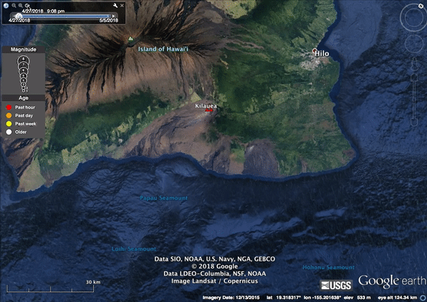
Earthquakes around Kilauea on the Big Island of Hawaii between 28 April and 4 May 2018. Orange circles occurred in the final 24 hours of the record. Data from the USGS catalogue.
What’s cool about this animation is that the patterns you can see in the seismic data match the activity on the volcano described above. As the Pu’u O’o lava lake started to drain on the 1st May, causing the crater floor to collapse, you can see a series of earthquakes migrating eastwards from Pu’u O’o, tracking the underground migration of the magma before it began to emerge from the fissures on the Leilani Estates subdivision (which is located exactly at the eastern edge of the yellow earthquake swarm). This nicely processed radar interferogram from Pablo Gonàzlez shows ground displacements that also match up with this narrative, with a long linear zone of intense deformation in the same region as the earthquake swarm. Both are caused by the magma draining sideways and down the Kilauea rift zone.
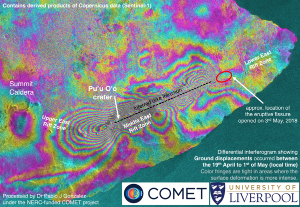
Ground displacements on Kilauea from comparisons of satellite radar measurements in Mid-April and early May.
Then yesterday evening, a large magnitude 6.9 earthquake struck the region, and the seismic activity afterwards appears to have largely shifted again, with main three clusters (orange and red circles) to the west of the epicentre and the fissure eruptions.
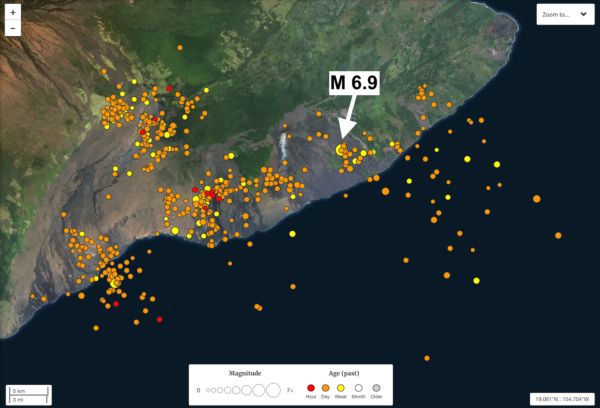
Earthquakes around Kilauea in the roughly 24 hours following a large magnitude 6.9 earthquake on 4th May 2018.
The focal mechanism of the earthquake – the largest earthquake recorded on Hawaii since a magnitude 7.4 in 1975 – indicates compression on a fault about 5 km below the surface. It is probably related the fact that the whole flank of Kilauea is sliding towards the sea. As the volcano is built upwards by eruptive activity, it spreads outwards along a weak detachment at the contact between the strong oceanic crust that the Big Island is built on top of, and the weaker jumble of fractured lavas and other volcanic debris that it is built from.
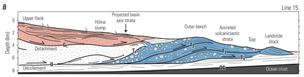
Interpreted seismic profile of the underlying structure of Kilauea’s south flank. From Denlinger and Morgan 2014 – USGS Professional Paper 1801, Chapter 4.
The most likely explanation is that the large earthquake yesterday evening was caused by sudden motion along this detachment or a fault associated with it: some preliminary GPS data from the USGS indicates that this is indeed the case.
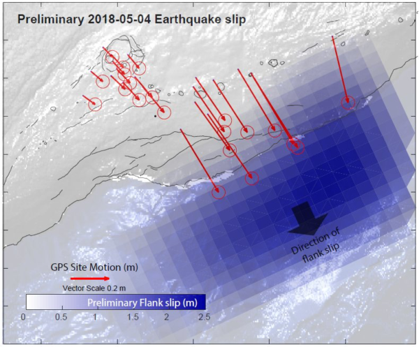
GPS data showing up to 0.5 m of motion due to M6.9 earthquake on 4th May, and displacements of up to 2.5 m on simulated rupture. Source: USGS Volcanoes on Twitter.
The three patches of earthquake activity after the earthquake are therefore probably located on the fault surface, and at the top and western edge of the bit of the volcano flank that just moved towards the sea.
What I am pondering right now is the relationship between this earthquake and the earlier magma movement from Pu’u O’o down to Leilani. I have annotated the radar image from above with the approximate location of the magnitude 6.9 earthquake. I think it is possible that the additional seaward stress applied by the dike intrusion helped to trigger this earthquake – although that is a little speculative at this point.
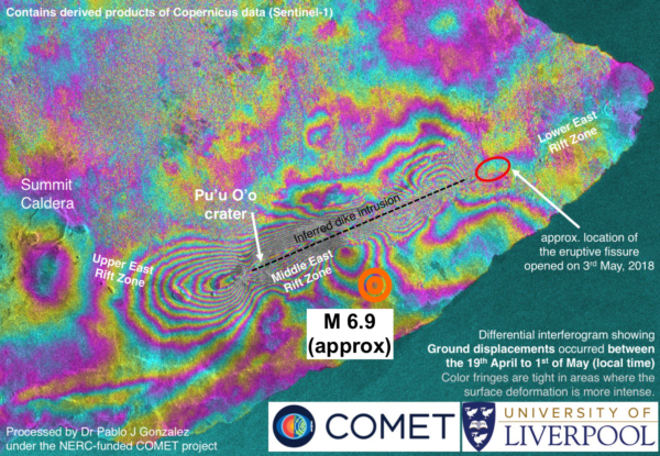
Large earthquake on May 4th located on radar interferogram, showing relationship between earthquake location and magma movement in preceding days.
We’ll also have to wait and see if this wider collapse of the flank of the volcano is going to have an effect on eruptive activity.
Comments (2)