
![]() Whilst touring Port Lockroy in Antarctica last Christmas Day, one of the exhibits describing the scientific research undertaken there had this interesting footnote:
Whilst touring Port Lockroy in Antarctica last Christmas Day, one of the exhibits describing the scientific research undertaken there had this interesting footnote:
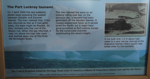
How Port Lockroy was almost washed away by a tsunami in 1946. Photo: Chris Rowan, 2013
This is pretty mind-blowing, if you think about it: an isolated Antarctic outpost at around 65 degrees South, being threatened by the effects of an earthquake at around 53 degrees North1. This is a powerful reminder of the long reach of a large subduction zone earthquake: the shaking is locally very destructive, but if it generates a tsunami then that destruction can be spread across a significant fraction of the planet.
Ten years ago today, we got a much more devastating reminder of this fact. A tsunami generated by a magnitude 9.2 earthquake off the coast of Sumatra radiated throughout the Indian Ocean basin. Waves up to 10 metres high engulfed heavily populated coastal regions from Indonesia and Thailand to Somalia, killing around 230,000 people. As the many sets of then-and-now photos being published this week show, the destruction was almost total. The scale of the disaster was magnified by the lack of any warning system for those in the path of the tsunami, who were taken by surprise and overcome even with several hours’ delay between the earthquake and the tsunami’s arrival.

Source: BBC
Sumatra was a tragic reminder of the power locked up in the world’s subduction zones. The last truly huge >M9 quakes to shake the earth before Sumatra had occurred in the early 1960s; a time when plate tectonics as we know it was still being pieced together. Indeed, George Plafker’s observations of patterns of uplift and subsidence in the wake of the 1964 M9.2 Prince William Sound earthquake was central to our recognition of the widespread existence of dangerous, shallowly dipping subduction zone thrusts around the edges of the world’s ocean basins. However, following that recognition subduction earthquakes in the plate tectonic era stayed their hands a little, with the largest magnitude earthquakes in the 1970s, 80s and 90s edging just above M8. Then, ten years ago today, a 40-year tectonic silence was broken.
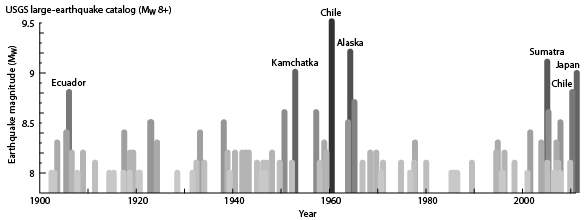
>M8 Earthquakes since 1900. Compiled from the USGS catalogue by Ground Truth Trekking
In the last decade a spate of >M8.5 earthquakes have shaken the Earth, caused a huge amount of death and devastation, and exposed the limits to our understanding of how earthquakes work. As I heard at GSA in October, megaquakes and large tsunami keep surprising us by happening where we don’t expect them to.
But our improving, if still limited, understanding of what happens in big subduction zone earthquakes does nothing if we can’t apply it: quickly determining which earthquakes are likely to generate tsunami and when and where they will strike, and then getting a warning to vulnerable coastal communities in time for them to evacuate. It is clear that the last 10 years have seen improvements in both tsunami forecasting and warning systems, although some issues remain in the Indian Ocean for getting timely warnings ‘the last mile’.
And I still wonder: can you ever be truly prepared for events of this magnitude? This summer, I spent a few days at a beach house on the Oregon coast. It was a beautiful place, but I found it difficult to feel totally comfortable there, given my knowledge of what lay off the coast, and what it was capable of.
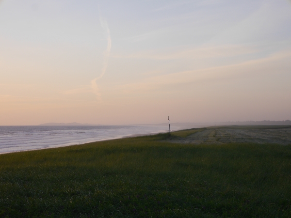
The flat coastal plain on the Oregon Coast. Many, many towns and beach houses are built on this. Photo: Chris Rowan, 2014.
Residents of this area have not by any means been left ignorant of the danger. The effects of a tsunami-generating earthquake on the Cascadia subduction thrust have been modelled. Safe areas have been mapped out, and evacuation routes signposted. I could see evidence of this up and down the coast, and even on the fridge of our beach house.
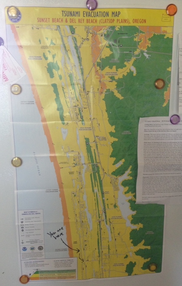
Tsunami Evacuation Map for the area I was staying in. All the yellow areas would be at risk from a tsunami generated by a Cascadia earthquake (not sure I trust the safety of the green ridges, either). Photo: Chris Rowan, 2014
But all I could see was how flat everything was, how far thousands of people would have to go to be truly safe, in not very much time. As we drove through all of the towns that hug the beachfront, all I could think about was how, when Cascadia decides it is time to move like it last did in 1700, all of this would get swept away.
Ten years after Sumatra, we’re still working to understand what happens when really big faults let rip. And despite the signs and the evacuation plans, I’m not sure we’ve truly grasped what it means to have a subduction thrust as your closest tectonic neighbour, either.
-
Estimates of the magnitude of this earthquake have increased over the years, from an unusually low M7.4 to a more recent estimate of M8.6. #
Comments (1)