
![]()
![]() My hometown lies on a sandbar, squarely in the floodplain of the Upper Mississippi River. Winona (Minnesota) benefited from its position along the river, rapidly growing to wealth as a steamboat port and lumber town. The second railroad bridge across the Mississippi was built there, and in 1900, Winona had more millionaires per capita than any other town in the country. In the last hundred years, the lumber industry in Winona has declined, but my town is still a major port on the Upper Mississippi and the river is the lifeblood of the community.
My hometown lies on a sandbar, squarely in the floodplain of the Upper Mississippi River. Winona (Minnesota) benefited from its position along the river, rapidly growing to wealth as a steamboat port and lumber town. The second railroad bridge across the Mississippi was built there, and in 1900, Winona had more millionaires per capita than any other town in the country. In the last hundred years, the lumber industry in Winona has declined, but my town is still a major port on the Upper Mississippi and the river is the lifeblood of the community.

Panoramic map of Winona (1889, Minnesota Historical Society)
But the same river that gave so much to my hometown also wrought destruction on Winona. From its founding in the 1850’s through the 1960’s, parts of Winona were repeatedly inundated by spring floods of the Mississippi River. Record flooding occurred in April 1965, and disaster in Winona was averted only by frantic sandbagging and the mysterious blow-out of a railroad dike a few miles downstream that released floodwaters into a wildlife refuge.

Flooding in Winona, 1880 (Minnesota Historical Society)

The Winona riverfront, protected by its high levee. Image from the Winona Daily News.
Following the 1965 flood, which crested at 20.77 feet, Winona built a massive 11-mile long levee that is designed to protect the city up to a river stage of 22 feet. The levee took nearly 20 years to complete, but now high spring flows pass Winona with little incident. The second largest flood in 81 years of record at Winona occurred in 2001, with the river cresting at 20.07 feet. A small parcel of parkland outside the levee was inundated, as it is many years, but otherwise the high water brought nothing but casual observers.
What is to be concluded from Winona’s story? Levees are good at protecting bits of land and communities where we’ve deemed it unacceptable that they be exposed to repeated floods. It’s not realistic to relocate all floodplain communities to higher ground – Winona, for example, has 25,000 people on a few square miles of land and is hemmed in by 500 ft bluffs – and if we are going to continue to use major waterways as transportation corridors, we need ports to get stuff on and off boats. Levees do a great job of minimizing impacts from moderate size floods. Ten out of 26 years since the Winona levee was completed have had peak flows above flood stage, so that’s nearly 40% of years where the levee has prevented flood damage and produced an economic benefit that will eventually equal its construction costs. In my mind, there’s no question that Winona is a place that benefits from and deserves its levee. I do acknowledge my bias in the matter, however, and I know that there are some serious negatives that come with levees.
People are drawn to settle on floodplains – because rivers provide transportation corridors, but mostly because floodplains are the most fertile soils on Earth. Those fertile soils are there because flooding creates floodplains, bringing in the sediment and nutrients that make rich, agriculturally-productive soils. I’d wager that every floodplain-dwelling person thinks that his or her home, farm, and community deserves protection from floods.
All along the Mississippi River and its tributaries, as settlers built farms and towns, their experiences echoed that of Winona. The river gave their land value (whether they realized the soil connection or not), but it also gave them misery. They wanted the benefits of the river, but not its floods. So they built levees, but often the locally-built levees were inadequate and failed repeatedly. In the late 1800s, the federal government took over and the US Army Corps of Engineers began a policy of building levees along the whole length of the Mississippi River from Cairo, Illinois, to its mouth – protecting millions of hectares of fertile farmland and hundreds of riverside communities. Or so they thought.

Levee overtopping and failure was so widespread in the 1927 Mississippi River flood, that sometimes there was no dry land left except atop the levees. Here, flood victims camp on a levee at Arkansas City, Arkansas (Corps of Engineers photo)
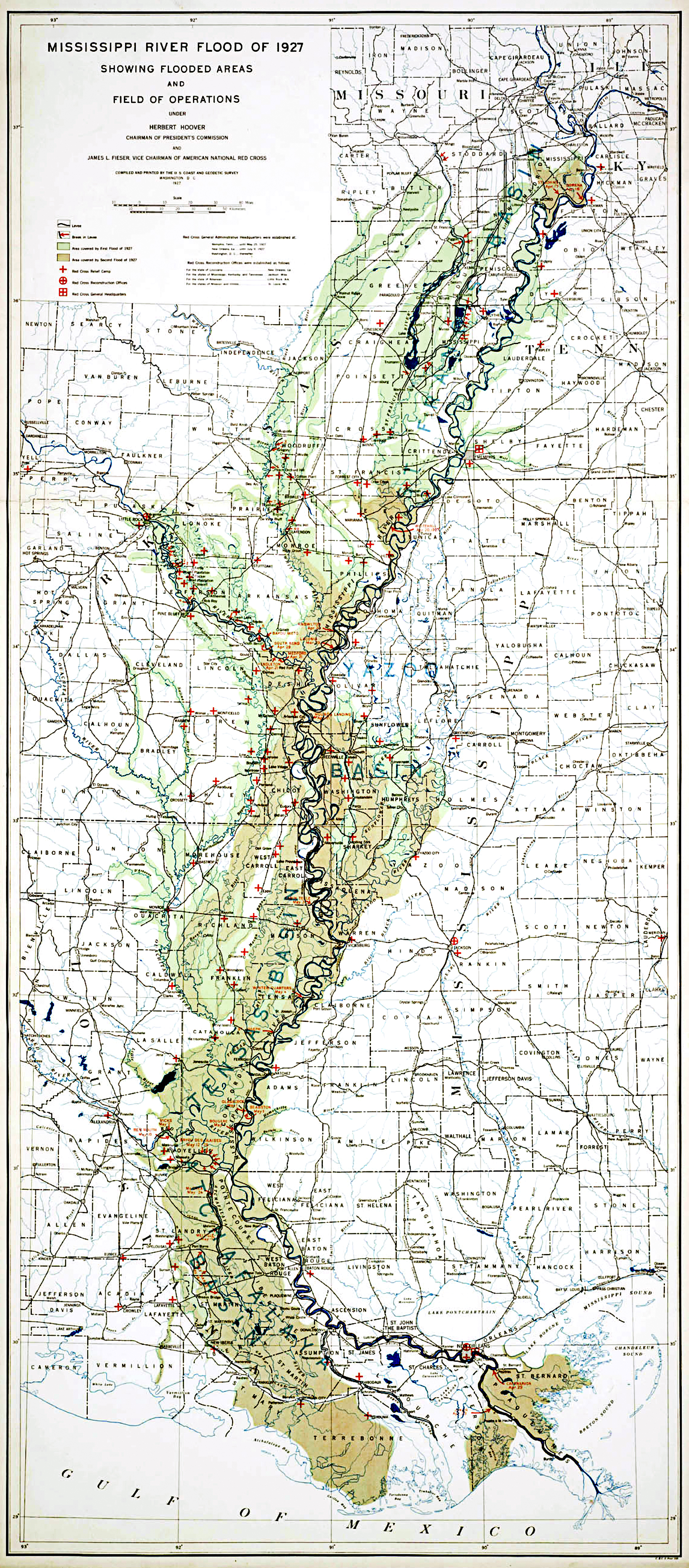
The great Mississippi River floods of 1927 showed the folly of depending on hundreds of miles of continuous levees to keep the floodplain dry. The 1927 flood was larger than anything that had come before it in the historical record, and the levees broke in at least 145 places, flooding 70,000 sq. km. In one spot, the flooding was 80 km wide (check out this spectacular – and large – map of the flood extent). More than a million people were displaced by the floods, and the cultural, social, and political ripple effects of the flood changed the nation’s history (I’m not exaggerating; read John Barry’s book Rising Tide for the gripping story).
The extensive leveeing of the Lower Mississippi River made the 1927 floods worse, just as all levees today carry consequences for current and future floods. While levees are good for individual communities in small- to moderate-size events, levees are bad for the river system’s overall capacity to deal with flood flows.
By literally walling off large sections of the floodplain, levees give the river much less room to spread out horizontally. This is obvious. It’s the reason that we build levees: to keep the river confined and out of our way. But levees basically do nothing to change the discharge, or volume, of the flood. So if the water can’t spread horizontally, it has to either speed up or get higher – and mostly the flood waters get higher. At St. Louis, the 1993 Mississippi flood peaked at a stage of 49 feet. In ~1927, the same volume of water at St. Louis would have reached only 39 feet. In the 66 years between the 1927 and 1993 floods, the cumulative changes to the Mississippi channel – including continued levee building – increased flood stage by 10 feet. At Chester, Illinois, the difference is 16 feet. In short, levees increase flood heights.

Winona is protected by levees, shown as red lines, and railroad dikes act as levees on the opposite side of the channel. The blue lines illustrate the approximate geomorphic extent of the floodplain. Above flood stage, the Upper Mississippi River has access to much less horizontal extent than it would naturally have, because of the levees. The magnitude of floodplain width reduction on the Lower Mississippi River is even more dramatic. (Image from Google Earth)
Levees even increase flood heights where they are not. The river is flowing along, flooding, and the flood wave is moving downstream, occupying the floodplain as it goes. Suddenly, it gets to a place where it is constricted by the levees, which are acting somewhat like a convergent nozzle. Some water goes through the constricted opening, but other water backs up and ponds behind the constriction.

Dynamiting the Mississippi River levee in St. Bernard Parish, 1927 (Corps of Engineers photo)
Removing levees immediately decreases flood height, by giving the river back temporary storage space on the floodplain. In Winona, in the 1965 flood, the town was saved from inundation by the breaking of a railroad levee ~15 km downstream. When that levee broke, the water at Winona dropped more than 20 cm in a few hours – just enough to keep the top sandbags above water. When the Bird’s Point Floodway was opened on May 3, 2011, water levels in the Mississippi at Cairo dropped more than 30 cm within hours. In 1927, powerful citizens of New Orleans decided to blow up a levee downstream of the city, flooding the residents of St. Bernard’s parish, in order to save themselves. As it turns out, unintended levee breaks that occurred a few hours before the dynamiting, upstream of New Orleans, would have kept the city dry anyways.
Not only do levees actually exacerbate floods, they are a static solution to a dynamic, probabilistic problem. Levee heights are based on knowledge of the past history of floods on the river system, estimates of precipitation that is likely to occur, and hydraulic analyses. On the Mississippi, the “project design flood” was developed in 1956 based on “the largest storm series considered to have a reasonable chance of occurrence in the season when floods are likely to occur over the Mississippi River Basin.” For reference, the Mississippi River at Vicksburg is currently flowing at 2,330,000 ft3/s (~66,000 m3/s), and the project design flood is 2,710,000 ft3/s. On Friday, the Mississippi River at Natchez is predicted to crest at 62.5 feet, almost 4.5 feet higher than the highest flood on record there. So the flood of 2011 on the Mississippi River is within the design standards of its levees, but what happens when a bigger flood comes along? Or what happens when a big flood comes along on a river where the levees aren’t so well designed and maintained?
Land use changes in a watershed can increase flood flows. As urbanization spreads impervious surfaces (e.g., parking lots) over larger areas, rainfall makes its way to rivers more quickly, contributing to increasing floods. Agricultural drainage and conversion of wetlands to farm fields also increases flooding. Levees built to withstand floods in a watershed with little urbanization and agricultural drainage may be inadequate after the land use patterns have changed.
Precipitation and snowmelt patterns also change, changing the frequency and magnitude of floods along with them. Increasing intensity of precipitation, a likely outcome of anthropogenic climate change, will contribute to increased flooding in the Mississippi watershed and elsewhere. Already, analysis of long-term flood records on the Upper Mississippi and Missouri suggests that annual peak flows are increasing in some areas, and that the likely cause is climate change (Olsen, 1999). This means that we need to recalculate the probability of a given size flood occurring each year. What was once thought to be a 1% probability event (“100-year flood”) now occurs with much higher probability. But, in a dynamic climate, it’s not entirely clear how to calculate flood probabilities in the way we’ve done in the past.
Levees aren’t designed to hold back every conceivable flood, and they are not perfect performers even when they are faced with more routine floods. Dams are often required to be designed to operate safely to the probable maximum flood worst-case scenario, but levees are usually built to a much more relaxed standard, something like the 1% probability (100-year) flood. When a flood comes along that’s bigger than that design standard, the levee will be overtopped or fail. And sometimes, levees fail even when the floodwaters are within the design criteria. One reason for opening the Bird’s Point Floodway in early May was concerns about levee failure at Cairo – even though they would have had several feet above the predicted crest, prolonged flooding could still have caused undermining or erosion that led to failure and catastrophic flooding of the city. The American Society of Civil Engineers (ASCE) report card on infrastructure gave the U.S. levee system a grade of “D-“, because more than 85% of the nations levees were privately built more than 50 years ago, are privately maintained (if at all), and were not designed for the current level of development behind them. The ASCE estimates it would take 100 billion dollars to repair and rehabilitate the levees of the U.S.

A levee breach on the Mississippi River near Elsberry, Missouri in the 2008 flood. (photo: Jocelyn Augustino/FEMA)
Every thoughtful analysis, from 1927 to 2011, has concluded that levees are not the sole solution to the Mississippi River’s flooding. After the 1927 flood, the Corps of Engineers added three floodways to their engineering arsenal. The Bird’s Point Floodway provides temporary floodplain water storage in a critical area just downstream of the Mississippi-Ohio junction. The Bonnet Carre and Morganza Floodways divert water from the river via alternate routes to the Gulf of Mexico. (All of these floodways are currently in operation.)

A levee protecting the town of Valley Park, Missouri from 2008 flooding of the Meramec River, a tributary of the Mississippi. (photo by the City of Valley Park)
But levees continued to be built all along the Mississippi River and its tributaries, and more people come to live and work on the floodplain. Since the 1993 floods on the Upper Mississippi River, more than 72 square kilometres of floodplain lands have been put behind levees in the St. Louis area alone (Pinter, 2005). Much of this land was under water in the 1993 flood. In the St. Louis area, 28,000 new homes have been built and 26.8 square kilometres of land has been developed for commercial and industrial use on land that was submerged in 1993. That means 10s of thousands of people are now living in the floodplain, protected only by an earthen wall. Land behind levees is open to any form of development, doesn’t show up as high risk on FEMA floodplain maps, and residents often don’t have flood insurance. Some don’t even have any idea that they are living on a floodplain. And that’s probably the biggest problem with levees. Levees create the illusion of safety that promotes further settlement and development of floodplain lands.
We’ve taken away enough of the natural floodplains of the Mississippi and other rivers. At the very least, it is time to stop building levees in undeveloped areas. But I think it is also time to make some more difficult choices about what areas we are going to return to floodplain functionality – giving the river back some space for spreading out and temporarily storing water during floods. Doing that will be better for the river ecosystem and safer for the more than four million residents of the Mississippi River floodplain.
Update: Steve Gough of Riparian Rap takes on some of these same issues, in the context of the on-going Mississippi River floods, in his post “Never ending flood suffering. A recipe.”
References Cited:
Barry, John M. 1998. Rising Tide: The Great Mississippi Flood of 1927 and how it Changed America. Simon and Schuster. 528 p.
Leopold, Luna B., 1994, Flood Hydrology and the Floodplain, in Coping with the Flood: The Next Phase, White, G.F., and Myers, Mary F., ed., Water Resources Update, Spring issue, p.11-15.
Olsen, J., Stedinger, J., Matalas, N., & Stakhiv, E. (1999). CLIMATE VARIABILITY AND FLOOD FREQUENCY ESTIMATION FOR THE UPPER MISSISSIPPI AND LOWER MISSOURI RIVERS Journal of the American Water Resources Association, 35 (6), 1509-1523 DOI: 10.1111/j.1752-1688.1999.tb04234.x
Pinter, N. (2005). ENVIRONMENT: One Step Forward, Two Steps Back on U.S. Floodplains Science, 308 (5719), 207-208 DOI: 10.1126/science.1108411
Comments (19)
Links (16)
-
-
-
-
-
-
-
-
-
-
-
-
-
-
-
-
Pingback: Flood Plains in the Desert : jfleck at inkstain
Pingback: ResearchBlogging.org News » Blog Archive » Editor’s Selections: Surface temperature record confirmed, Levees debunked, And More Efficient Solar Power from Nanowhiskers.
Pingback: Earth Buzz – The News Roundup : Earth Matters : Blogs
Pingback: Stuff we linked to on Twitter last week | Highly Allochthonous
Pingback: Flooding Around the World | Highly Allochthonous
Pingback: Behind The Heavy Drapery | Whimsy Speaks
Pingback: And on to the finals! — OH, FOR THE LOVE OF SCIENCE!
Pingback: Flooding around the world (early June edition) « Watershed Hydrogeology Blog
Pingback: Stuff we linked to on Twitter last week | Highly Allochthonous
Pingback: Ataraxia Theatre » Archive » After The Meeting
Pingback: Anne is a “Strange Quark” « Watershed Hydrogeology Blog
Pingback: Chirality and the Positron’s Mustache | Cosmic Variance | moregoodstuff.info
Pingback: Anne is a Strange Quark, AKA awesome science writer! | Highly Allochthonous
Pingback: 3 Quarks Daily Prize! | Neurotic Physiology
Pingback: Chirality and the Positron’s Mustache | Cosmic Variance | Theoretical Physics
Pingback: blowing the fuse – mammoth // building nothing out of something