![]() Fargo, North Dakota is coming out of its 3rd snowiest winter since 1885. Snow continued to fall into late March, and daytime temperatures have only been above freezing for few weeks. At night, it’s still below freezing, though starting tomorrow night the forecast calls for above freezing minimum temperatures. Soils are already saturated, and more rain is possible this weekend.
Fargo, North Dakota is coming out of its 3rd snowiest winter since 1885. Snow continued to fall into late March, and daytime temperatures have only been above freezing for few weeks. At night, it’s still below freezing, though starting tomorrow night the forecast calls for above freezing minimum temperatures. Soils are already saturated, and more rain is possible this weekend.
In short, it is perfect flood weather for the Red River that runs along the Minnesota-North Dakota border and into Canada. This is a place with the perfect geography for extensive flooding, and a long history of big spring floods.
Every town along the Red River has been devastated by a flood more than once. So they’ve all got emergency response plans in place for weather just like this. For example, Moorhead (Minnesota, across the river from Fargo) has a nifty GIS feature that shows how each foot of flood water affects each city block.
Residents are already filling sand-bags to build temporary levees. But with year after year of flooding, and with successful sand bag efforts the last two years, some residents might be taking this year’s flood predictions in a somewhat complacent fashion. But looking at the National Weather Service’s North Central River Forecast Center projections, there’s plenty of reason for concern all along the Red River.
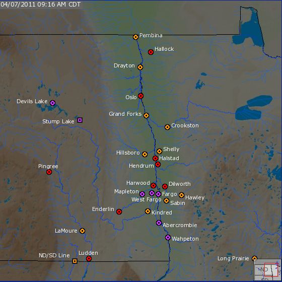
As of 9 am Central time on 7 April 2011, most of the US portion of the Red River is already above flood stage, but water levels will continue to rise almost everywhere for at least the next week.

Current flood levels along the Red River and nearby drainages, as of 9 am, Thursday 7 April 2011. Orange circles indicate minor flooding, red indicates moderate flooding, purple indicates major flooding. Screenshot from the North Central River Forecast Center, using data supplied by the USGS.
The flood wave will move downstream – from south to north. In Wahpeton, a crest is expected today, with a second – equally high if not higher – crest next week. There the flood crest is likely to fall a few feet short of record water levels set in 1997.
Between Wahpeton and Fargo, tributaries to the Red River are having major flooding as well – in part because of backwater effects from the main river. If the Red River is flooding, there’s no place for water flowing down the tributaries to go. Instead they back up, causing even more widespread flooding.
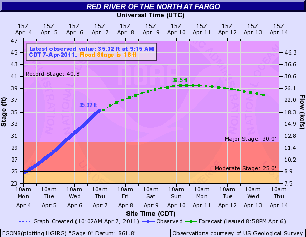
In Fargo (ND) and Moorhead (MN) – which have a combined population of 200,000 people – the flood will not crest until late Sunday. Right now, the National Weather Service is predicting a crest of 39.5 feet, which 1.3 feet short of the record flooding of 2009. However, there some chance that the river will crest at 41 feet, or even higher if there is precipitation in the next few days. Currently, 80% of the city is protected by sand bags and levees to a height of 41 feet, but those may need to go even higher.
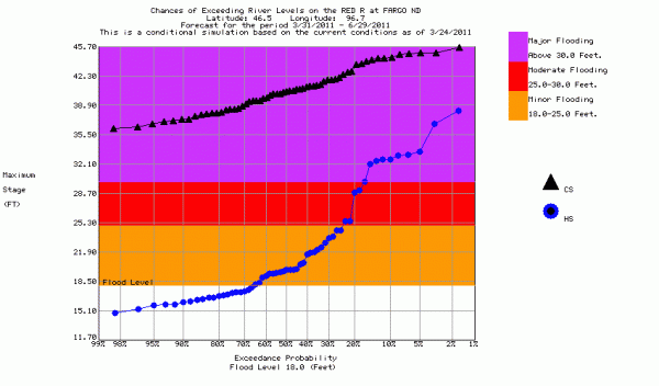
Two weeks ago, the National Weather Service issued a longer-term flood forecast for the Red River at Fargo. At that time they considered it a 10-50% percent chance that the river would reach 40 to 44.3 feet by mid-April. They provided a probability of exceedence curve for their modeled projections of this year’s flood season against the historical record of flooding, as shown below. To understand this graph, it helps to look at a few specific points. Right now, the river is at 35.32 feet. Based on the outlook from two weeks ago, it was virtually inevitable that the river would reach this level, with a probability greater than 98%, as shown by the black triangles. In contrast, 35.32 feet is reached less than 5% of the years in the historical record for Fargo, as shown by the blue circles. The current projected crest of 39.5 feet was given about a 50% chance of being exceeded as of two weeks ago, yet it has only be reached twice (1997, 2009) in 111 years of record. Two weeks ago, the National Weather Service was saying that there was a 25% chance the river could go above 42 feet, which is higher than the top of the sand bag levees now being prepared.

NC River Forecast Center's 90 model showing the Red River at Fargo's chances of exceeding certain water levels, relative to the historical record.
The short term forecasts, like the one two above, have better skill than long term forecasts like the immediately above, but the long term forecasts are vital for emergency managers, city officials, and riverside land-owners in making early plans for the flood. The reason they’ve got all the sand and sand bags on hand in places like Fargo is because they knew there was a good chance a really big flood was coming. They’ve been talking about it since January.
Downstream (north) of Fargo-Moorhead lies Grand Forks, with about 100,000 people in its metropolitan area. Grand Forks was swamped by the flood of 1997, but the current forecasted peak stage this year is about 3.5 feet lower, though the crest won’t reach Grand Forks until late next week. For now, they are watching the water levels and making their preparations. Downstream further, lies Winnipeg, Manitoba. The flood crest won’t reach there until late April, but already the river is 17 feet above normal winter stage, and only 5 feet below the 2009 flood peak. Needless to say, they too are sand-bagging.
But for the next few days, the action focuses on the Fargo-Moorhead area. You can check out the updated data and forecasts or you can watch the flood play out in Moorhead with a live webcam pointed at the downtown waterfront:
Watch live video from 702 Flood Cam – Moorhead on Justin.tv


Links (3)-
-
-
Pingback: Why does the Red River of the North have so many floods? | Highly Allochthonous
Pingback: Floodwaters rising on the Red River « Watershed Hydrogeology Blog
Pingback: Stuff we linked to on Twitter last week. | Highly Allochthonous