The subduction zone off the west coast of Chile, where the Nazca plate is being thrust beneath America, has generated some of the largest earthquakes ever recorded, including a magnitude 9.5 in 1960 that remains the largest earthquake ever recorded on a seismometer.
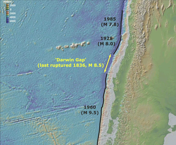
On February 27th last year, the subduction zone ruptured again, with the epicentre only 115 km northeast of Concepción, Chile’s second largest city. The magnitude 8.8 earthquake that ensued – together with the tsunami generated by movement of the seafloor above the rupture zone – killed more than 500 people and caused billions of dollars’ worth of damage. It also occurred in a section of the plate boundary that had not ruptured for almost 200 years. In 1836, Charles Darwin experienced a large earthquake, with an estimated magnitude of 8.5, that destroyed Concepción. Since then, the plate boundary to the north has ruptured in large earthquakes, in 1928 and 1985, and a 1000 km stretch to the south was involved in the 1960 magnitude 9.5. But until 2010, the portion of the plate boundary that ruptured in 1836 remained stuck, producing a ‘seismic gap’: a portion of the plate boundary where significant strain has been accumulated, but has yet to be released in an earthquake. This particular seismic gap is sometimes referred to as the ‘Darwin gap’, in honour of the scientist who recorded its last significant activity.

Ruptures on the Chilean subduction zone in the last 100 years. The 'Darwin Gap' is a segment of the plate boundary that has not ruptured since 1836.
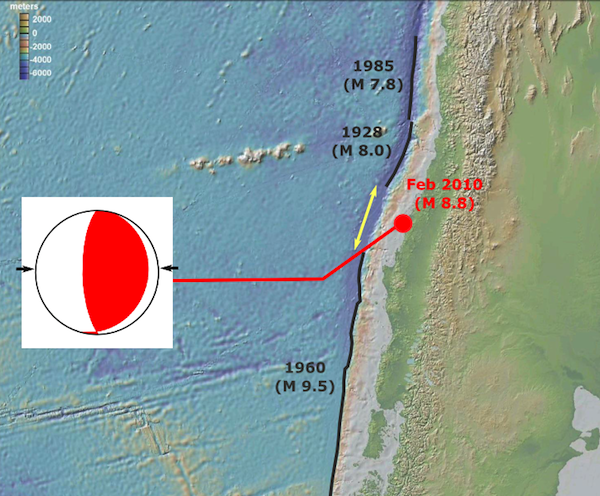
The Nazca and South American plates are converging at a rate of almost 7 centimetres a year, or 7 metres a century; this means that by 2010 around 12 metres of slip had accumulated in the Darwin Gap since 1836. The region was primed for a large earthquake, that would release all this strain and fill the gap, and at first glance this is exactly what happened in February 2010. The point of rupture was within the gap, and the focal mechanism shows it occurred on a shallowly dipping thrust fault, as you would expect for a subduction zone earthquake.

Location and focal mechanism for the M 8.8 earthquake of February 27th 2008. The earthquake was a compressional rupture at a point within the Darwin Gap.
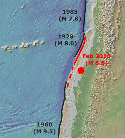
If the Darwin Gap had been filled in, those rebuilding from the devastation caused by the earthquake could at least take comfort from the fact that the strain built up in the crust since 1836 had been released, and the risk of further large shocks in the near future had been reduced as a result. But a new paper by Lorito et al. argues that this was not actually what happened last February. The earthquake deformed the continent and the seafloor around the rupture. Radar and GPS measurements allow precise measurements of the former, and the latter can be calculated using observations of the direction and magnitude of the tsunami that was generated as it moved through the Pacific basin. By combining these datasets, Lorito et al. were able to model exactly how the plate boundary deformed following the initial rupture. What they found was that the subduction zone within the Darwin gap did not actually slip very much at all during last February’s earthquake. Instead, the initial rupture propagated north, with the most slip – 10-20 metres – occurring in the same region as the 1928 earthquake.

Extent of the February 2010 earthquake, according to the modelling of Lorito et al. Most movement on the subduction thrust (solid line) was north of the initial rupture, with only a small amount of slip in the Darwin Gap (dotted line).
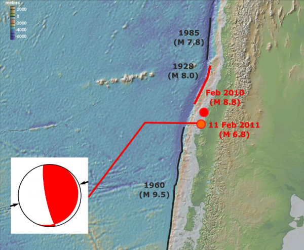
What does this mean? For starters, it means that the Darwin Gap – and the accumulated strain from a couple of centuries of subduction – persists, and represent a significant seismic hazard for Chile. In fact, Lorito et al. calculate that last February’s earthquake increased the stress on the plate boundary in the gap, potentially increasing the risk of another major earthquake in the area. In fact, as I was preparing this post, the USGS has reported a magnitude 6.8 earthquake within the Darwin Gap. The focal mechanism shows it is a compressional earthquake occurring on a fairly shallow (25 km), gently dipping thrust, meaning it is probably on the subduction boundary. Fortunately early reports indicate that the Chileans have escaped further serious damage or casualties; unfortunately, this latest earthquake will, at best, relieve a small portion of the energy stored on the plate boundary. The seismic gap probably endures.

Location and focal mechanism of the M 6.8 earthquake that occurred as I was writing this post on 11th February 2011.
At a broader level, this study highlights how much we still don’t understand about how plate boundaries work. The plate motions that are accommodated at places like the Chilean margin appear smooth and relatively steady over geological timescales, but over shorter timescales they are nothing of the sort. Not only is motion within any particular segment of the boundary very stop and start, with strain accumulated over decades and centuries released by earthquakes in seconds and minutes, but the size of different segments, and the frequency and magnitude of the earthquakes they produce, can also be quite variable. Although it is clear that stress changes due to earthquakes in adjacent segments are important, a simple model of sequential ruptures, where a rupture in one segment puts more stress on adjacent ones and cause them to rupture in turn, is ruled out by the existence – and persistence – of seismic gaps.
Lorito, S., Romano, F., Atzori, S., Tong, X., Avallone, A., McCloskey, J., Cocco, M., Boschi, E., & Piatanesi, A. (2011). Limited overlap between the seismic gap and coseismic slip of the great 2010 Chile earthquake Nature Geoscience DOI: 10.1038/ngeo1073


Comments (3)