![]() When I teach hydrogeology, one of my labs early in the semester focuses on giving students a hands-on feel for one of the essential hydrogeologic properties of earth materials- porosity.
When I teach hydrogeology, one of my labs early in the semester focuses on giving students a hands-on feel for one of the essential hydrogeologic properties of earth materials- porosity.
Porosity is the ratio of voids to solids in the material, and tells us the maximum amount of water a rock or sediment can hold. Porosity is a function of the original grain size and shape (what we call primary porosity), and any cementing, fracturing, or dissolution since emplacement (secondary porosity). Sometimes, not all the void spaces can actually be reached by water, meaning that the effective porosity can be lower than the total porosity. It’s also important to note that porosity can be quite different than permeability, which is the ease with which a fluid moves through a porous material. The next lab the students do focuses on that concept, but first they get to use rock cubes to learn about porosity.

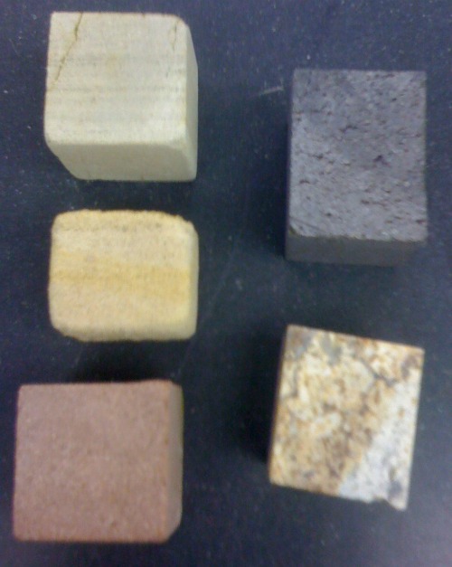
Cubes for measuring porosity. Left column (from top): Eau Claire Formation, Mt. Simon Sandstone, and Chequamegon Sandstone. Right column: basalt and metagranite.
Students are given the five cubes pictured above and asked first to identify their rock types (hope they don’t read the blog!) and they hypothesize about the relative porosity of the samples. Then they measure porosity by two methods: gravimetric (comparing bulk to grain density) and volumetric (submersing the samples in water for 24 hours in a graduated cylinder). I ask them to discuss potential sources of error or uncertainty in their methods and to think about whether they are measuring total or effective porosity. The basalt and metagranite samples are handy for getting them to think about how porosity of a small sample may not be representative of a whole formation. In the North Carolina Piedmont and mountains, rocks like that metagranite are our aquifers, but the flow is entirely through interconnected fracture systems.
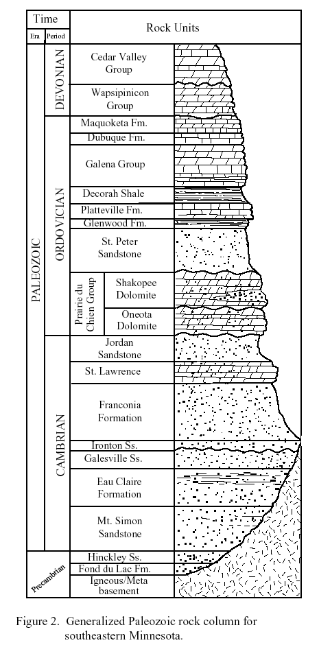
The three sedimentary rocks pictured above are in the lower part of the stratigraphic sequence of southeastern Minnesota, as shown below (source here).

Stratigraphic column of southeastern Minnesota. The Hinckley Sandstone is equivalent to Wisconsin's Chequamegon Sandstone.
Using some standard relationships, I ask the students to calculate the hydraulic conductivity of the formations and suggest which of them would make good aquifers. One of those rocks is a principal aquifer in much of the northern Midwest. Another is variously considered either an aquifer and a confining layer depending on its local properties. One of my goals for next summer is to collect samples higher in that stratigraphic sequence, in order to get students thinking about porosity and permeability in carbonate rocks.
Want kids get their hands on rocks before they get to college? How about helping Denver first graders get a “rock solid” education? Or New York City 6th graders examine rocks and minerals?


Comments (3)
Links (1)-
Pingback: The Driftless Area: Fewer glaciers but more topography than the rest of Minnesota | Highly Allochthonous