
 Welcome to the latest edition of the Accretionary Wedge geoblogging carnival. We’ve been delighted by the response to our call for your favourite geological imagery, and the number of nominations we’ve received has been matched by their diversity – images have ranged from the microscopic to continental scales, from the depths of geological time to the present day, from the igneous to the sedimentary. The only way we could think of to do this smorgasboard of earth science justice was in the form of a visual dictionary, matching the images you’ve provided to the feature or process that they exemplify. Clicking on each image will allow you to see it in all its full-resolution glory at the original post, which in many cases also provides some more background on the geological feature or process depicted. Fun, pretty and at least a little bit educational – we hope you’ll have as much fun looking through our little glossary as we had putting it together.
A
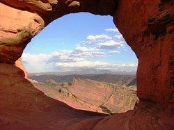
Arch, natural – Formed by differential erosion at the base of a narrow ridge.
Photo: Arch, Arches National Park from Geotripper
B
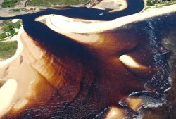
Beach – deposit of unconsolidated sediment (sand, gravel, or shell fragments) at the land-water interface. One of many coastal zone morphologies.
Photo: Unknown beach with channel deposits. From Michael Welland.
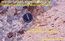
Breccia – coarse sedimentary or volcanic rock with angular clasts
Photo: Pyroclastic breccia, Eagle Mtns, west Texas. From geosciblog.
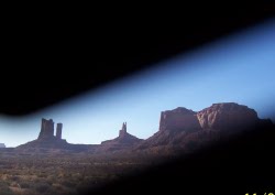
Butte – prominent, isolated hill with steep sides and flat top. Smaller than a mesa.
Photo: Monument Valley by Dino Jim.
C
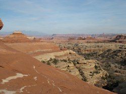
Canyon (or gorge) – a deep, steep-sided valley, often formed by a river incising into a plateau or mountain range.
Photo: Canyonlands National Park from Geology Happens
Coastal zone – region where interaction of terrestrial and marine processes occurs. Morphology can take the form of a beach, barrier island, delta, cliff, or wave-cut platform.
Photo: Ebb-tidal delta – eastern Brazil. From Geologia Marinha e Costeira.
Conglomerate – coarse sedimentary rock with rounded clasts.
Photo: Ogallala/Arikaree formation near the Pawnee Buttes in north eastern Colorado (conglomerate butte landscape) from Russ Dale
D
Debris flow – type of mass wasting where large clasts are carried in a mud-water mixture.
Photo: Debris flows, Pacific NW. From Anne Jefferson
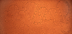
Dessication cracks – fractures formed by the shrinkage of clay, silt, or mud as it dries out from subaerial exposure.
Photo: Riviere de Terre – natural ‘artwork’ featuring dried, cracked clay. From Pools and Riffles.
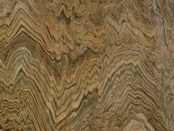
Diagenesis – post-depositional alteration of sediments at low temperatures and pressures, often leading to the growth of new minerals in response to changing geochemical conditions.
Photo: pendant calcite crystals precipitated within meteoric aquifers during late Ordovician sea-level fall, Appalachians. From Suvrat.
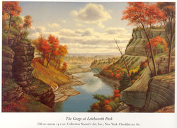
Differential weathering – divergence in the degree of weathering and erosion of different lithologies exposed to the same environment. Differential weathering is a factor in the formation of arches, buttes, and mesas, as well as steep slopes where some layers form vertical cliffs and other rock layers have subvertical exposures.
Picture: Letchworth State Park in Castille, NY, painted by Levi Wells. From John van Hoesen.
E
Exposure – the amount of geology that is exposed on the surface, and not hidden by pesky vegetation, soils, etc.
Photo: Cerro Divisadero, Patagonia, from Brian Romans
Extinction event – abrupt disappearance of species, often as a result of extreme environmental changes, which can also result in a prominent lithological boundary. Significant (mass) extinction events include:
– K/T (or K/Pg) boundary, 65 million years ago
Photos: (top) KT boundary at Stevns Klint in Denmark. From olelog.
(bottom) KT boundary, Makoshika State Park, Montana. From Geology Blues
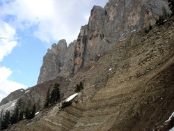
– Permo-Triassic boundary, 250 million years ago.
Photo: Permo-Triassic transition, Dolomites, N Italy. From Nologic.
F
Folding – deformation of formerly horizontal layers of rock, usually due to compression.
Photo: Kings Canyon National Park. From Helena Heilotrope
_, plunging – non-horizontal fold axes, due to later deformation events.
Photo: Lamurde Anticline, from Failed Rift.
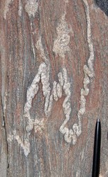
_, ptygmatic – occurs in sequences with high viscosity contrasts between layers.
Photo: ptygmatic folding in metagraywacke, from Callan Bentley.
_, overturned, recumbant – where high deformation leads to inversion of stratigraphy in fold limbs.
Photo: overturned syncline at Dog Canyon, Big Bend National Park. From Antonio
G
Gooseneck – the pinched bit of land in an extremely bowed stream meander.
Photo: Goosenecks, Utah. From Failed Rift.
Gullywasher – an intense rainstorm that activates ephemeral channels.
Photo: the most epic rainstorm of Kyle House’s life.
H
Hematite – iron oxide (Fe2O3), a common product of weathering and other low temperature alteration.
Photo: Hematite sheets, Red River Gorge, Kentucky. From Stubotics
J
Jointing – rock fractures with no displacement across the fracture. Can be the result of regional stresses or cooling of volcanic rock.
Photo: Long’s Peak, from Pascal
K
Kyanite – an aluminum-rich silica mineral (Al2SiO5), commonly deep blue in color, that generally forms during high pressure metamorphism.
Photo: Metamorphic kyanite, Scotland. From Life-Long Scholar
L
Landslide dam – formed when a landslide blocks a river valley, these natural dams impound water upstream. Such dams can create hazards if the upstream impounded water floods property or if they suddenly overtop or breach releasing a flood wave downstream.
Photo: Attabad landslide, Hunza, N. Pakistan from Dave’s Landslide Blog
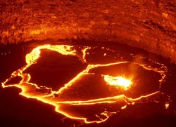
Lava Lake – body of mostly molten lava contained within a depression over a volcanic vent.
Photo: Erta Ale, Afar, Ethiopia from Chris Rowan
M
Mesa – tableland with steep sides and flat top of uplifted, erosion-resistant rock. A mesa is generally larger than a butte.
Photo: North Caineville Mesa, just east of Capitol Reef National Park in southern Utah. From Jim Repka.
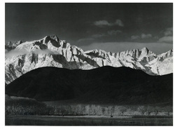
Mountain – the natural habitat of the geologist.
Photo: Ansel Adams, Winter Sunrise, Sierra Nevada. From Lockwood.
O
Ooids – round, concentrically layered sedimentary grains, usually of calcium carbonate.
Photo: Photomicrograph of ooids in a Jurassic carbonate, from Lost Geologist
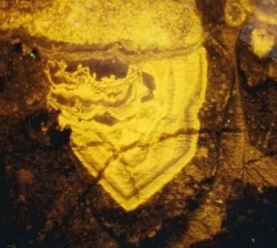
Ore – rocks containing high concentrations of economically useful minerals.
Photo: Gold with naumannite (Ag2Se), Northern Nevada. From Silver Fox.
P
Pioneer Species – the first organisms to colonise bare land, either newly created or swept clean by fire or flood.
Photo: First colonisation of lava flow by plant from Magma Cum Laude.

.
Power Law Creep – a type of deformation where small increases in applied stress leads to greatly increased strain rates. Thought to control deformation in the mantle explaining how you can get extremely rapid mantle flow around subducting slabs.
Picture: model of mantle flow around subducting Alaskan slab, from Discovery News.
Precipice – often encountered by single minded geologists in search of the perfect outcrop.
Photo: from Kyle House.
S
Seismic Reflection Survey – controlled release of sound waves to examine the subsurface structure of the Earth. Modern computer processing provides extremely high spatial resolution.
Photo: Buried paleo-channels in Gulf of Mexico. From Hindered Settling.
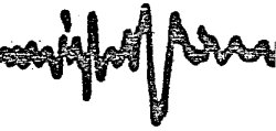
Seismogram – a visual record of ground motions due to an earthquake.
Photo: Seismograph for Mb 6.0 earthquake beneath the Kermadec Islands on Sept 21, 1981, recorded at Adelaide, Australia. From Hypocentre.
T
Tilting – regional deviation of beds away from the horizontal, usually in response to regional tectonic uplift.
Photo: Tilted sandstones, Fountain Valley, Roxborough State Park near Denver, Colorado. From Russ Dale
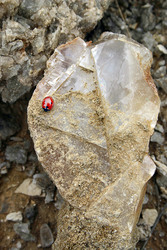
Twinning – where a crystal is subdivided into regions with different lattice alignments.
Photo: twinned selenite (sparry gypsum), from Lutz.
V
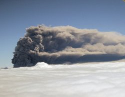
Volcano – an opening in the Earth’s surface through which lava, ash, or gases are erupted. Volcanoes chiefly occur in regions where rifting, subduction, or hot spots have triggered melting of the mantle.
Photo: Mt St Helens – volcano above a subduction zone. From Short Geologist.
Photo: Eyjafjallajokull, Iceland – volcano at a rift zone from
Eruptions.


Comments (25)