![]() It’s now been just over 3 weeks since a magnitude 7.0 earthquake hit Haiti, devastating the capital Port-au-Prince and many other surrounding towns and villages. The sheer scale of the disaster – the tens, even hundreds of thousands who have lost their lives, or their homes and families – has been quite overwhelming. As the country struggles to recover and rebuild, and with aftershocks still occasionally shaking things up, one question that people want answered is, are we safe yet? When is the continued seismic activity going to stop? Will there be another devastating earthquake in the future – and if so, when? And what about the rest of the northern Caribbean?
It’s now been just over 3 weeks since a magnitude 7.0 earthquake hit Haiti, devastating the capital Port-au-Prince and many other surrounding towns and villages. The sheer scale of the disaster – the tens, even hundreds of thousands who have lost their lives, or their homes and families – has been quite overwhelming. As the country struggles to recover and rebuild, and with aftershocks still occasionally shaking things up, one question that people want answered is, are we safe yet? When is the continued seismic activity going to stop? Will there be another devastating earthquake in the future – and if so, when? And what about the rest of the northern Caribbean?
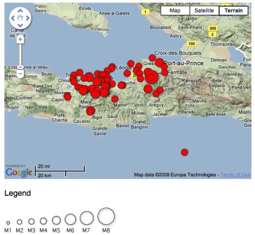
Let’s start with the aftershocks. When a fault ruptures, the surrounding crust will be deformed by the motion. The upper crust is brittle, so will accommodate this deformation by rupturing at further points of weakness like minor faults and fractures, causing aftershocks. As of February 2nd, there have been 62 significant aftershocks powerful enough to be picked up by the global seismograph network. The USGS provide a handy map (which is being updated over time; this is a static snapshot):

Source: USGS
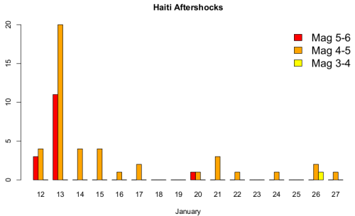
If we plot the frequency of aftershocks over time, we see that the vast majority occurred in the 24 to 36 hours following the main shock (which occurred quite late on the 12th January). This period also included about 15 aftershocks with a magnitude greater than 5, whilst there has only been one (a magnitude 5.9) since.

This makes sense: most of the response to the local redistribution of stress in the crust following a large earthquake will occur almost immediately, as weak points are pushed beyond their point of failure. But there will be some places where stress was increased almost to the point of failure, but not quite over it, and will finally fail a bit later. This means that although there doesn’t seem to have been a significant aftershock for a week (although there were probably smaller ones that weren’t properly picked up by distant seismometers), there’s still the risk of a strained part of the crust finally giving, producing a sizeable aftershock, for some time yet. Which is why this USGS assessment predicted, based on statistical modelling of the aftershocks in the week or so following the mainshock, 2 or 3 aftershocks of magnitude 5 or greater would occur in the 30 day period after 21st January, with a 25% chance of a magnitude 6 or greater aftershock.
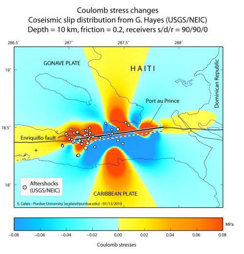
However, focussing on just the aftershocks ignores what seems to be the real concern about future seismic risk in Haiti: namely, that only an approximately 40 km long segment of the Enriquillo Fault ruptured on January 12th, and in the same way that stress redistribution around the ruptured section causes aftershocks, stress transferred onto adjacent, and as yet unruptured, sections of the Enriquillo Fault might well trigger large earthquakes on them. This worry has a precedent. In the aftermath of the magnitude 9.0 Boxing Day 2004 Sumatra earthquake, John McCloskey and his colleagues at the University of Ulster calculated that this rupture had placed more stress on the subduction megathrust further to the southeast. Less than a month after publishing a warning of the increased seismic hazard, there was a magnitude 8.7 earthquake in the area in question. It seems that a similar process may possibly be at work in Haiti; here’s a map of the stress changes resulting from the January 12th earthquake, as modelled by Eric Calais (I originally found this on a brilliant collection of scientific imagery for the Haiti earthquake being collated by the Group on Earth Observations). Note that the aftershocks (circles) are clustered in the red areas indicating the largest stress increases, but also note the stress increases in the region surrounding the Enriquillo fault both to the east and the west.

Modelled stress changes for the Jan 12 earthquake: thick line marks the modelled rupture length.
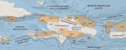
As always when talking about triggering earthquakes, it is important to emphasise that this is just giving already strained bits of crust an extra nudge that might cause them to rupture a bit earlier than they otherwise would. The worry comes from the fact that these fault segments might just have enough strain stored up on them to be primed for such triggering. The historical map below shows that a large section of the Enriquillo-Plantain Garden Fault system running through southern Haiti and the neighbouring Dominican Republic last ruptured in a sequence of earthquakes concentrated in a 20 year period between 1750 and 1770, meaning that prior to January 12th, more than 250 years’ worth of tectonic movement between the North American and Carribean plates (or, more precisely, the fraction of that tectonic motion that is accommodated by this fault) was being stored as elastic strain across the Enriquillo fault.

Source: New York Times
Eric Calais was co-author of a 2008 paper (pdf) that used GPS measurements to estimate the rate that strain was building up on the Enriquillo fault, extrapolated from that the total elastic strain accumulated on the Haitian part of the fault zone since the last big earthquake, and calculated that if it was all released in a single earthquake, it would have had a magnitude of approximately 7.2. Some of that strain has now been released by the magnitude 7.0 three weeks ago, but it might be less than you instinctively think: the earthquake magnitude scale is logarithmic, so a magnitude 7.2 earthquake represents about 1.6 times more energy than is released by a magnitude 7.0 earthquake. This leads to the conclusion that the unruptured parts of the Enriquillo fault, particularly the part to the east of January’s rupture (which is still very close to Port-au-Prince), still represent a significant seismic hazard.
Another look at the earthquake history of Haiti and the Dominican Republic also reveals a second potential earthquake hazard. The northern Septentrional Fault System seems (from current, GPS-derived, deformation patterns), to accommodate just as much tectonic motion as the Enriquillo system. The part of the Septentrional Fault that runs through Haiti last ruptured in 1842, and has built up enough strain to potentially cause a magnitude 6.9 earthquake if it all ruptured in one go. But there are no historically recorded earthquakes on the part that runs through the Dominican Republic, and paleoseismic studies (which look for disruption of datable horizons in trenches dug along the fault) indicate it probably last ruptured almost 1000 years ago. If that’s right, there’s enough strain stored up on this section to cause up to a magntiude 7.5 earthquake.
To sum, up then, despite January’s quake releasing a fair amount of the strain built up at the plate boundary, there’s still plenty more yet to be released in this part of the Caribbean. Seismologists can’t really predict if the recent earthquakes have increased the chances of this remainder being released sooner rather than later; more data is definitely required about how the crust has responded to the last month of shaking and stress changes, both through close study of comparative radar imagery (several examples are up at the Group on Earth Observations site), and getting on the ground to make more GPS measurements. However, what should not be ignored is that regardless of the details, this region is always going to be at risk from these sorts of earthquakes. The strain still being stored on the Enriquillo and Septentrional faults is going be released at some point in the decades to come, and it’s just a question of when, and how (multiple ruptures, or one big one?). But even then, the danger will not disappear – the slow yet inexorable motion of the North American and Carribean plates will place strain across these faults again – including the segment that caused so much carnage three weeks ago – and eventually they will rupture again. After that, the earthquake cycle will restart once more until they rupture again, and again, and again. The tectonic rhythms of our planet are slow, and a few hundred years of inactivity on a fault is a mere eyeblink when its lifetime can be measured in hundreds of thousands, even millions, of years.
Whilst geologists can not – and may not ever – be able to predict exactly when an earthquake will hit, we are getting to the stage where we know where they are most likely to strike, and roughly how big and how frequent they are likely to be. The northern Carribean is seismically active, and will remain so until what is, for us, an unimaginably distant point in the future. Making the people who live there aware of the seismic risks is important: even after 50 years pass and last month’s tragedy fades from the Haitians’ memories, geologists need to press home the fact that it will happen again, and people should plan and build – and live – accordingly.
Categories: earthquakes, geohazards, geology
Tags: Haiti earthquake geohazards seismology tectonics


Comments (6)
Links (1)-
Pingback: Tectonics of the Haitian earthquake | Highly Allochthonous