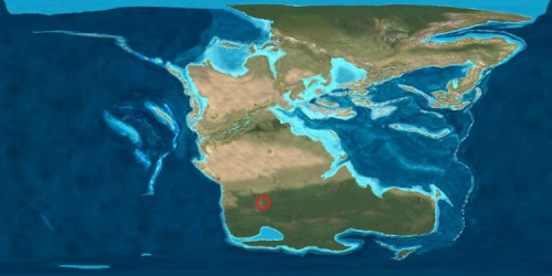
Over the weekend Chris of Goodschist challenged the geoblogosphere to reappropriate Pangaea Day, by taking advantage of Ron Blakey’s fantastic palaeogeographic maps to show where the rock beneath our current abode was located on the dinosaur-laden Mesozoic supercontinent. Callam and Brian have both responded, and I’m belatedly weighing in:

In the late Triassic (around 220 million years ago), South Africa was actually pretty much where it is now in terms of latitude, but it was located in the centre of a much larger landmass (often referred to as Gondwana) consisting of Africa, South America, India, Antarctica, and Australia, which had amalgamated several hundred million years earlier, and then collided with Laurentia (North America) and the other ancient continents to form Pangaea towards the end of the Permian. Since then, of course, all of these other landmasses have rifted away, forming the modern oceanic basins which now separate them.


Nice plan for content warnings on Mastodon and the Fediverse. Now you need a Mastodon/Fediverse button on this blog.