
This is a guest post from Anne Jefferson, an assistant professor at the University of North Carolina at Charlotte. She’s a hydrogeologist who likes to play in rivers, and I let her post this on the condition that she not show me up by being clearly smarter and a better writer than I am – I’m not convinced that she stuck to her side of the bargain, though…
As the casualty count continues to climb in China’s Sichuan province following the May 12th M 7.9 earthquake, authorities are struggling to provide shelter and prevent disease amongst the 5 million people displaced by the quake. Seismologists are warning that there is still the potential for large aftershocks, and many people are still jittery. But there’s also another potential danger lurking in the mountain valleys of Sichuan province – that of floods of water released by the failure of dams.
Some of these dams are man-made and suffered structural damage in the earthquake, like the 150 m Zipingpu dam near Dujiangyan. NPR reported:
One of its abutments sank 10 centimeters (4 inches). The force of the earthquake opened cracks in the dam wall. But, officials say, Zipingpu remains structurally stable and safe.
Still, here’s an ominous thought: the reservoir at Zipingpu can hold up to 1.1 billion cubic meters of water. The Water Resources Ministry says the city of Dujiangyan, with a population of more than 600,000 people, “would be swamped” if the dam failed.
An even more ominous threat is from landslide dams. During the earthquake, large landslides were knocked loose from the steep mountain slopes and came to rest in the narrow valleys below. The landslide deposits can block river flow and create a reservoir upstream. Eventually the water level will overtop the dam, and the reservoir will stabilize. Unless, of course, the erosive power of the overtopping is enough to cause dam failure, the pressure of the water is stronger than the unstable dam can support, or an aftershock destabilizes the deposits.
In the week following the quake, 24 lakes had formed in the area affected by the earthquake. NASA has incredible images of one of those lakes, filling the valley and flooding two villages.
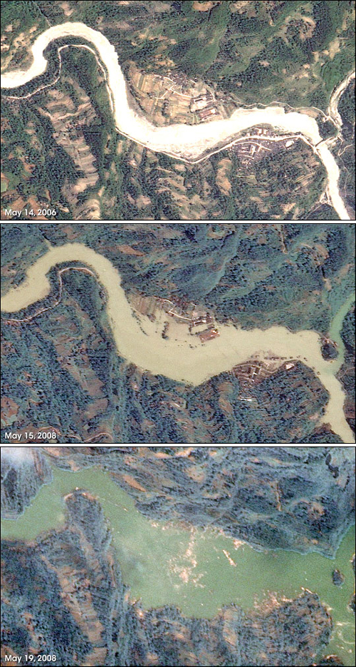
The largest dam appears to be 3.5 km upstream from Beichuan, a town of 30,000 that has been the hardest hit by the earthquake and resulting landslides. This dam is apparently still inaccessible because of blocked roads in mountain passes, but it is reported to be 2 km long and blocking the Qingjiang River. Another dam is 70 m high and 300 m wide, and it blocked the Chaping River and destroyed a hydropower station. A smaller dam is 7 m high, 33 m wide, and 100 m long, and it holds back 606,000 cubic meters of water. At least one evacuation has already taken place when a landslide dam threatened to burst. Researchers are trying to develop plans to safely drain the lakes before catastrophe occurs.
This isn’t the first time Sichuan province has faced this threat. In 1786, a M 7.75 earthquake triggered a landslide that blocked the Dadu River. F.C. Dai and colleagues (2005) did meticulous historical and geomorphic research to reconstruct the events that followed. The landslide dam was 70 m high and held back 50 million cubic meters of water in a reservoir area of 1.7 square kilometers. A large aftershock hit the area 10 days after the main quake, and it caused the dam to fail. The resulting flood had a peak discharge of ~37,000 cubic meters per second, but the real tragedy is that the flood killed 100,000 people living downstream. The landslide dam on the Dadu was not spectacularly large (the largest existing landslide dam is in Tajikstan and is 550 m high), but the deaths from downstream flooding make it the most catastrophic dam failure on record.
Journal articles cited:
Dai et al. 2005. “The 1786 earthquake-triggered landslide dam and subsequent dam-break flood on the Dadu River, southwestern China” Geomorphology 65: 205-221. doi:10.1016/j.geomorph.2004.08.011.
Stone, R. 2008. Landslides, flooding pose threats as experts survey quake’s impact. Science. 320:996-997. doi:10.1126/science.320.5879.996.
Other news sources are linked above.
Comments (5)