
For various reasons mostly beyond my control, I haven’t really had time to write an entry for for this month’s Accretionary Wedge, the theme for which is “(Un)Favorite Geological Misconceptions”. Fortunately, this very subject was the theme of a post from way back in the early days of ye olde blog. Since this was also a time when my readership wasn’t much larger than me (and I half expected it to remain that way), I feel quite justified in dusting it off, giving it some polish (since I have revisted some of these themes in later essays) and reposting my list of pet peeves. As for the ‘pie’ sub-theme, I’m with Julia: most good pies are savoury pies, and steak and stilton pies are the best of the lot. But I digress.
Tectonic plates move around on top of a sea of molten lava. Many people mistakenly believe that the beneath the Earth’s crust lies a seething mass of molten lava, ready to erupt at any minute. Not true. As the figure below shows, although the temperature of a rock does increase with depth (as shown by the red line, the geotherm), so does its melting point due to the immense pressure exerted by tens of km of rock piled on top of it.
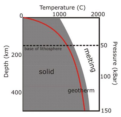
As you can see, at no point does the geotherm cross the solidus (the temperature at which melting would start), so the rocks remain solid even at great depths. However, below about 150-200km, the geotherm gets quite close to the melting point, which allows rocks to more easily deform and flow (a process known as creep). Think less molten lava, more Silly Putty. Mantle convection can therefore occur below this depth, even though the rocks are not melted. The more rigid, non convecting rocks above this boundary form the lithosphere, which forms the major part of tectonic plates (the crust is just a skin on top).
Melting to form magma, and hence volcanism, only occurs when something happens to disrupt this situation; three common ways that this happens are shown below. The geotherm can cross the solidus by being shifted upwards by rifting (which thins the lithosphere and allows upwelling of hotter mantle to shallower depths), or across by a mantle plume (an upwelling of hotter material from deeper within the Earth). The melting point of the mantle rocks can also be reduced by a change in composition; at subduction zones, this is caused by the addition of water from the downgoing plate.
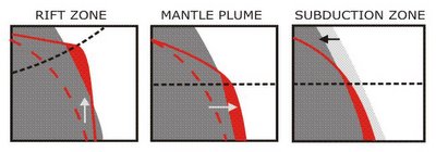
This is the reason why volcanoes only occur in particular geological environments on the Earth’s surface, rather than everywhere.
What earthquake and volcano ‘prediction’ actually means. Sorry folks, but it’s never going to get to the stage where we can point to a particular volcano or fault and say, “this will erupt/rupture next Thursday at 11:00”. For both volcanoes and faults, geologists can try and reconstruct the past history of eruptions and earthquakes, to see how regularly they happen. They can also watch for signs of imminent activity: the filling of a volcano’s magma chamber might be accompanied by small earthquakes and ground uplift; the build-up of strain across a fault can be monitored by GPS. This gives some clues as the the likelihood of something happening, but it’s just that – a probability, not a certainty. Volcanoes and faults are complex systems which exhibit chaotic behaviour – large changes in outcome are caused by tiny variations in the initial conditions. In the case of a fault, sometimes when a small section of the fault fails, the rupture remains very localised and you get a small earthquake, only detectable by instruments; sometimes that small rupture will trigger failure over a much larger section of the fault and cause a big earthquake. So although you can easily measure when a lot of strain has built up across a fault, predicting which of the many tiny earthquakes, that happen all the time, is going to turn into the big one which releases it all is probably impossible (as is explained in much more detail here).
So, unfortunately, the most precise forecast you’re ever going to get is, “there’s a high (or low) likilihood of rupture or eruption in the immediate future”. And, particularly for earthquakes, “immediate future” could well mean “in the next decade or two”…
There is one ‘geological column’ for the whole Earth. The geological timescale divides the 4.5 billion years of earth history into distinct chunks, based on changes in environment or dominant forms of life over time. However, this does not mean that every rock of a particular age is the same. Just like today, in these periods many different processes were leaving their own unique record; marine deposits formed in shallow seas, deltas built out from coastlines, deserts formed vast dune fields. In other places, uplift of ancient mountain ranges led to no deposition, and erosion of rocks that had been laid down in earlier times. So there is no one geological column; each area has its own unique sequence of rock types, often with large time gaps in between different units. Correlating them all with each other is one of the major tasks of the geologist (see also last year’s more detailed debunking of this misconception).
All radiometric dating is ‘carbon dating’. You wouldn’t believe how many times this has come up in undergraduate exam papers (hopefully not as a result of anything I said in lectures), let alone amongst the wider public: the notion that all radiometric dating involves 14C. It’s the isotope most people have heard of, because it is so widely used in archaeology. However, trying to ‘carbon date’ rocks of any sort except for very young sediments is generally pointless; 14C has a half-life of 5,730 years, which means after about 50,000 years it has virtually all gone. Assuming there was anything to begin with, of course; there’s not generally much carbon in volcanic rocks. This doesn’t matter, because there’s a whole array of different isotopes with half-lives much better suited to dating rocks tens of millions of years old.
Reversals of the Earth’s magnetic field are instantaneous.
Because it is generated by vigorously convecting molten iron in the outer core, the Earth’s magnetic field is quite dynamic by geological standards: the magnetic poles shift their position by around 10 kilometres every year. A more extreme type of behaviour is the periodic reversals of the field’s polarity: every million years or so, north becomes south and south becomes north. However, this does not mean that we could wake up tomorrow and discover all our compasses pointing in the wrong direction. Although detailed and well-dated records of a field reversal are quite hard to come by, those that we have found indicate that the reversal process actually takes several thousand years to complete. The magnetic dipole field gradually weakens, and then there is a period where the magnetic field goes a little haywire: there may be more than one magnetic north pole, meaning that your compass will point in entirely different directions depending on where you are on the Earth’s surface, and they can move further away from the geographic poles than they currently do, even to the equator or the opposite hemisphere (more technically, the magnetic field energy that is presently found in the dipolar field is probably instead used to generate quadrapolar or octapolar fields). Eventually the dipole field begins to strengthen again, and since both a ‘normal’ and ‘reversed’ polarity field are equally stable, it will often regenerate in the opposite polarity to the one that preceded the collapse.
It all sounds quite wild, but in reality these changes all happen at pretty much the same rate as the secular variations in the field that we’ve been seeing for the last few hundred years, meaning that it would take us at least that long again to notice ‘reversal-like’ behaviour, and it’s certainly not anything which is going to crash ships, screw up computer systems or fry us all with cosmic rays a la The Core.
A geologist can tell you the life story of a random pebble you’ve picked up on the beach. Don’t get me wrong, pebbles can be useful – they tell you about local rock types along that section of coast, for one thing, which is very handy when you’re mapping. Just don’t be disappointed when the most information you get from me is ‘sandstone’. The most interesting geological information often comes from features which are only found at larger scales than a pebble – where a particular rock type occurs in a sequence, for example, or the sedimentary structures or deformation that are found in large outcrops.
Blowing up Earth-bound comets and asteroids at the last minute will save the day.. Nope, we’d still be doomed (OK, this is tenuous geologically, but it does annoy me).
Comments (16)