
Wilkins has been letting guest bloggers rain on my geological parade. Fortunately for him, it has brought this little gem to my attention – a global map (the BBC is providing a link to a larger pdf version) of variations in the magnetisation of the Earth’s crust.
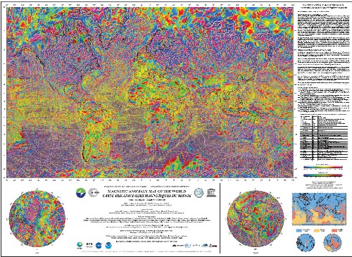
The Digital Magnetic Anomaly Map (click on the image for a larger version in your browser)
As I’ve discussed previously, the Earth’s magnetic field is generated in the outer core, and on a large scale roughly resembles a dipole located close to the rotation axis. If you examine it closely, however, you will discover lots of short-wavelength deviations from this simple pattern – the field shows slight increases and decreases away from its expected dipolar values (referred to as magnetic anomalies) as you move around over the Earth’s surface. These variations are evidence that additional magnetic sources are contributing to the geomagnetic field, and their small area of influence indicates that these sources are quite close to the surface: in other words, they’re in the crust.
The total magnetisation of a rock has two components. Firstly, paramagnetic minerals within the rock (pretty much anything containing transition metals with unpaired d-orbitals) align their magnetic moments with the field generated by the outer core, resulting in an induced magnetisation. This is a transient effect: if the geomagnetic field collapsed, the induced magnetisation would quickly vanish. However, any rocks containing ferromagnetic minerals will also have an intrinsic remanent magnetisation which is stable even in the absence of an external field and often records an ancient field direction dating from the time of the rock’s formation.
One thing that this global compilation illustrates really well is that the magnetic anomalies associated with oceanic and continental crust are very different in character. In most places oceanic crust has a striped appearance, with long, narrow positive and negative anomalies paralleling the mid-ocean ridges. The positive anomalies represent crust formed in periods where the geomagnetic field had the same polarity as today, so have a remanent magnetization which boosts the background geomagnetic field; the negative anomalies represent crust which formed in reversed polarity intervals, so their magnetisation cancels out some of the background field. As Chris Nedin explains in his guest post at Evolving Thoughts, these striped magnetic anomalies were the key to proving that oceanic crust is generated at mid-ocean ridges, which is one of the fundamental tenets of plate tectonics. However, they also establish that magnetic anomalies in oceanic crust are almost entirely caused by remanent, rather than induced, magnetisations. This is partly because oceanic basalts usually have very strong remanent magnetisations, because they contain large amounts of stable ferromagnetic minerals like magnetite. But it is also a result of oceanic crust’s homogeneity: because it has pretty much the same composition and thickness everywhere, there is very little variation in induced magnetisations across ocean basins.
This strongly contrasts with continental crust, which is much more variable in composition, having hung around for billions of years to be faulted, rifted, uplifted, and intruded. Continental crust is therefore far from homogeneous, with large contrasts in magnetic susceptibility, and therefore induced magnetizations, between adjacent areas. Granites and sediments are also generally far less rich in ferromagnetic minerals, so it is these differences, rather than remnant magnetisations, which generally cause the much more irregular anomaly patterns that you see on the continents. Below I’ve zoomed in on South Africa, and highlighted some of the more prominent anomalies (Jo’burg is the white circle) :
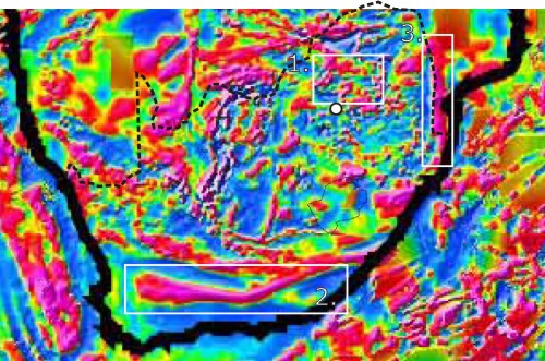
- The ring-like positive anomaly to the north of Jo’burg is probably due to the presence of the Bushveld Complex: a massive, 2 billion year-old intrusive body which contains obscene amount of economically useful minerals (it contains more than half the world’s known inventory of platinum, for example)
- I’m not completely sure exactly what this very prominent E-W oriented anomaly represents, but it seems to be associated with the Late Palaeozoic Cape Fold Belt, an orogenic belt linked to the amalgamation of Pangaea
- The Mesozoic break-up of Pangaea has also left it’s mark: the N-S oriented anomaly along the west coast north of Durban is due to a strip of the Early Jurassic Karoo flood basalts which accompanied the earliest rifting (oddly, the Karoo basalts which form the Drakensburg mountains in and around Lesotho do not show up in a similar fashion).
The first example illustrates the economic importance of magnetic surveying; ore bodies often have susceptibilities orders of magnitude higher than their host rocks, making it a very useful geophysical technique to employ in the search for things like iron ore. However, as the other examples show, the complicated magnetic anomaly patterns found on the continents is the end result of many different geological processes.
I really wish this map had come out earlier – it was exactly what I needed for one of the courses I taught back in Southampton. Still, it’s a valuable resource for the future.


Comments (5)