
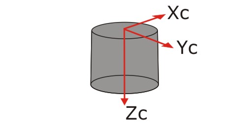
Paleomagnetism has many complications and subtleties – as I’ve learnt the hard way in the last six years, it’s not a simple matter of sticking your sample in the machine and getting a direction out. For a start, the direction that the magnetometer initially spits out is often not in a geologically meaningful reference frame. The magnetic intensity of a sample is usually measured along orthogonal x, y and z axes, defined such that the top of a sample is the x-y plane, and the z axis points downward through it.
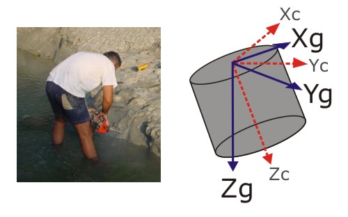
However, if we examine a paleomagician in the act of drilling for a sample, we see that he is drilling into the outcrop at an angle. Therefore, the x-y plane defined by the top of the sample does not correspond to the real horizontal plane; neither does the z-axis of the core point straight down with respect to the Earth. This skewing of the co-ordinate axes means that the direction of the magnetic vector you measure in the lab is also skewed away from the ‘real’ direction. Plus, because each core is drilled at a different angle, this skew will be different for every sample from an outcrop, so even very similar actual magnetization directions might appear to be very different as measured.
It’s even more complicated than that if your sample is recording the ancient magnetization you’re hoping for. Such a magnetization is recording a direction with respect to the horizontal at the time the formation that you are studying was deposited, and because most geological units are tilted by tectonic activity in the millions of years since they formed, the paleohorizontal (or, more technically, the ‘stratigraphic’ co-ordinate axes) are also rotated with respect to the present day horizontal (‘geographic’ co-ordinate axes).
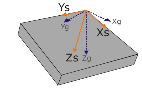
Therefore, for your measurements of remanent magnetization to be useful, you need to measure the orientation of both the cores you drill, and the formation you’re sampling. Then, with a bit of trigonometric fiddling (which can thankfully be done by computer nowadays), the core measurements can be used to rotate the magnetic vector back into the geographic co-ordinate system (which allows you to check for the presence of present-day field overprints, acquired after the rock was tilted), before the bedding measurements are used to rotate the vector back into stratigraphic co-ordinates, revealing the true ancient field direction.
Obviously, then, you need to be very careful about measuring the orientation of cores and beds; get it wrong, and you find yourself in the wrong co-ordinate system with a whole load of meaningless results. Last week, I was trying to unravel the data of someone who very nearly suffered such a fate; a former PhD student here at UJ, who did a little bit of paleomag work as part of his thesis. When I reanalysed his tilt-corrected data, I was very surprised to discover that my calculated directions were completely different from the ones published in his thesis. Even more disturbingly, when I looked at his original analyses I found very little correspondence between the raw data and the calculated directions.
Part of confusion was cleared up when one of the student’s supervisors (who gave me the data to look at in the first place) remembered that the original bedding measurements used for the tilt correction were wrong (they had been measured at a place where the beds were locally deformed, so were not representative of the whole outcrop). A bit of digging through the data files confirmed that the bedding measurements used to correct the data I was using were entirely different from the measurements cited in the thesis. Therefore all I needed to do was rotate my fits back into geographic co-ordinates using the old (incorrect) tilt correction, then apply the new (correct) one, and all would be well. Great – except that I couldn’t get it to work. As a test, I used the old corrections to transform the tilt-corrected data back into geographic co-ordinates, and found that they didn’t match up with the originals. The correction I was using obviously wasn’t quite right.
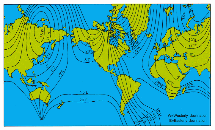
A great deal of muttering and head scratching later, I finally realised why – I’d neglected another reference frame issue. Compass bearings are relative to magnetic, rather than geographic north, and in South Africa the former is 15-20 degrees anticlockwise of the latter (e.g.). Normally published bearings are corrected for this, but in this case they hadn’t been.
And after all that, I still don’t agree with the original analysis. But at least now I’m fairly sure that that’s not just because I’m comparing things calculated in different co-ordinate systems.


Comments (1)